Home > North America > United States of America > New York > New York > Maps
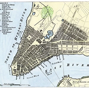
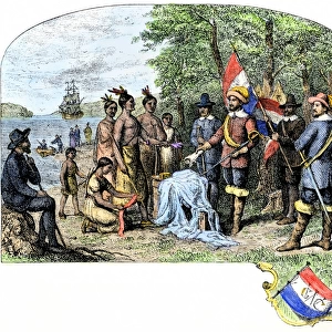
New York harbor chart, 1733

![]()
Wall Art and Photo Gifts from North Wind
New York harbor chart, 1733
Popples map of New York City and the surrounding area, 1733.
Hand-colored woodcut reproduction of an 18th-century illustration
North Wind Picture Archives brings history to life with stock images and hand-colored illustrations
Media ID 5882559
© North Wind Picture Archives
1700s 18th Century Atlantic Atlantic Ocean Chart Colonial Colonist Colony English English Colony Harbor Manhattan New Jersey New York New York City 1733 Elizabeth Long Island Newark Popple Sandy Hook Staten Island
FEATURES IN THESE COLLECTIONS
> North America
> United States of America
> New Jersey
> Elizabeth
> North America
> United States of America
> New Jersey
> Newark
> North America
> United States of America
> New York
> New York
> Manhattan
> Related Images
> North America
> United States of America
> New York
> New York
> Maps
> North America
> United States of America
> New York
> New York
> Staten Island
> Related Images
> North Wind Picture Archives
> Maps
> North Wind Picture Archives
> New York City
EDITORS COMMENTS
This vintage print captures the essence of New York City's rich history and colonial heritage. The hand-colored woodcut reproduction showcases an 18th-century illustration known as the "New York harbor chart, 1733" by Popples. This artwork takes us back in time to a bustling era when Manhattan was still a small English colony. The intricate details on this map reveal the significance of New York Harbor as a vital hub for trade and exploration during that period. From Staten Island to Long Island, from Newark to Sandy Hook, every corner of this historic region is meticulously depicted. The chart also highlights the majestic Atlantic Ocean that played a crucial role in shaping the city's destiny. As we gaze upon this piece, we are transported to an era where colonists embarked on adventurous journeys across these waters, laying down foundations for what would become one of the most iconic cities in North America – New York City. This artful representation serves as a reminder of our roots and how far we have come since those early days. It symbolizes our connection with the past while celebrating our progress into modernity. Let this print be cherished not only for its aesthetic value but also for its ability to evoke nostalgia and appreciation for New York City's enduring legacy.
MADE IN AUSTRALIA
Safe Shipping with 30 Day Money Back Guarantee
FREE PERSONALISATION*
We are proud to offer a range of customisation features including Personalised Captions, Color Filters and Picture Zoom Tools
SECURE PAYMENTS
We happily accept a wide range of payment options so you can pay for the things you need in the way that is most convenient for you
* Options may vary by product and licensing agreement. Zoomed Pictures can be adjusted in the Cart.