Home > Animals > Mammals > Muridae > Magnus
PROY2A-00017

![]()
Wall Art and Photo Gifts from North Wind
PROY2A-00017
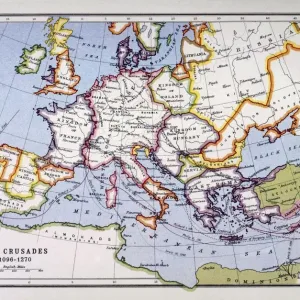
Map of Europe in the time of Charlemagne, 768-814 AD.
Printed color lithograph, 19th century
North Wind Picture Archives brings history to life with stock images and hand-colored illustrations
Media ID 5882669
© North Wind Picture Archives
700s 800s 8th Century 9th Century British Isles Empire Europe European France Great Britain Holy Roman Empire Medieval Mediterranean Sea Middle Ages North Sea Scandinavia Carolus Magnus Charlemagne Cordova
FEATURES IN THESE COLLECTIONS
> Animals
> Mammals
> Muridae
> Magnus
> North Wind Picture Archives
> Maps
> North Wind Picture Archives
> Royals:rulers
EDITORS COMMENTS
This vintage print showcases a meticulously detailed map of Europe during the reign of Charlemagne, spanning from 768 to 814 AD. The stunning printed color lithograph, created in the 19th century by North Wind Picture Archives, transports us back to the medieval era with its rich historic significance. The illustration depicts an expansive view of Europe, stretching from the British Isles in the northwest to Cordova in the southwest and Slavia in the northeast. It beautifully captures key regions such as France and Scandinavia while highlighting significant bodies of water like the North Sea and Mediterranean Sea. At its center lies Charlemagne's vast empire, known as the Holy Roman Empire or Carolingian Empire. This powerful realm dominated much of Western Europe during this period and left an indelible mark on history. As we delve into this artful representation, we are transported through time to witness how kingdoms rose and fell within these borders. The map offers a glimpse into a world shaped by political alliances, cultural exchanges, and territorial conquests that defined European history throughout the Middle Ages. This remarkable piece serves not only as a visual delight but also as a valuable educational tool for understanding Europe's geopolitical landscape during one of its most influential periods.
MADE IN AUSTRALIA
Safe Shipping with 30 Day Money Back Guarantee
FREE PERSONALISATION*
We are proud to offer a range of customisation features including Personalised Captions, Color Filters and Picture Zoom Tools
SECURE PAYMENTS
We happily accept a wide range of payment options so you can pay for the things you need in the way that is most convenient for you
* Options may vary by product and licensing agreement. Zoomed Pictures can be adjusted in the Cart.