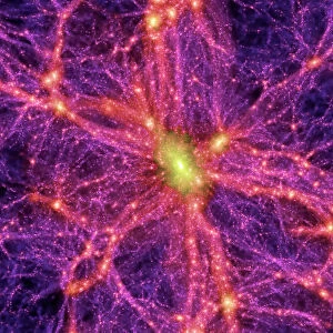
Fraud Blocker Skip to main content

Home > Europe > France > Paris > Maps

Dark matter map

 : Dark matter map
Sold 4
In Stock
We accept all major payment options so you can pay for the things you need in the way that is most convenient for you

Choose Your Product


Science Photo Library Photo Prints and Wall Art

Dark matter map

Dark matter map. Computer model of a dark matter (red) map in part of the universe a billion light years long, the first time the invisible dark matter between visible objects has been mapped. Its position has been inferred from the effect its gravitational pull has on the light (yellow lines) from galaxies (blue). Without dark matter, these lines would be straight. The mass of the visible universe is only about a tenth of that calculated from observations, and dark matter is thought to constitute the missing mass. This work was done by Yannick Mellier and his team from the Paris Astrophysics Institute, France, using the Canada- France-Hawaii Telescope on Mauna Kea, Hawaii, USA. Science Photo Library features Science and Medical images including photos and illustrations. © YANNICK MELLIER/IAP/SCIENCE PHOTO LIBRARY

Media ID 6444231

Canada France Hawaii Telescope Cfht Cosmology Dark Matter Gravitational Lens Lensing Universe

FEATURES IN THESE COLLECTIONS

> Animals > Mammals > Muridae > Sua

> Europe > France > Maps

> Europe > France > Paris > Maps

> Europe > France > Paris > Related Images

> Europe > Italy > Veneto > Este

> Maps and Charts > France

> Maps and Charts > Related Images

> North America > Canada > Maps

> North America > Canada > Related Images

> North America > United States of America > Hawaii > Related Images

SECURE PAYMENTS
We accept all major payment options so you can pay for the things you need in the way that is most convenient for you

Made in Australia
Safe Shipping, Easy Returns

FREE PERSONALISATION
We are proud to offer a range of customisation including Cropping, Captions, and Filters. Zoom Cropping can be adjusted in the basket


EDITORS COMMENTS

This print showcases a groundbreaking achievement in the field of astrophysics - a computer model of a dark matter map spanning an astonishing billion light years. For the first time ever, scientists have successfully mapped the invisible dark matter that exists between visible objects in our universe. The red hues represent this elusive substance, which has been inferred from its gravitational pull on light, depicted by the mesmerizing yellow lines emanating from galaxies (shown in blue). The significance of this discovery lies in unraveling one of the greatest mysteries of our cosmos. The mass calculated solely from observable entities is merely a fraction compared to what is expected based on observations. Dark matter is believed to account for this missing mass and understanding its properties could revolutionize our comprehension of the universe's structure. Yannick Mellier and his team from the Paris Astrophysics Institute, France, conducted this pioneering work utilizing data obtained through the Canada-France-Hawaii Telescope located atop Mauna Kea in Hawaii, USA. By employing gravitational lensing techniques and advanced computational models, they were able to construct this intricate map. This awe-inspiring image serves as a testament to human curiosity and ingenuity as we strive to unlock the secrets hidden within our vast cosmic landscape. It reminds us that there is still so much left to explore and comprehend about our enigmatic universe.


Framed Prints of Dark matter map

Discover the mysteries of the universe with our stunning Framed Prints from Media Storehouse. This captivating piece features a computer model of a dark matter map, an invisible force that has only recently been mapped in part of the universe, one billion light years long. Add this intriguing Dark Matter Map by Science Photo Library to your collection and bring the wonders of science into your home or office. Each print is expertly framed and ready to hang, making it a perfect gift for the science enthusiast or anyone who appreciates the beauty and complexity of the universe.


Photo Prints of Dark matter map

Explore the mysteries of the universe with Media Storehouse's Photographic Prints featuring the stunning "Dark Matter Map." This captivating image, sourced from Science Photo Library, showcases a computer model of a billion-light-year expanse of the universe, where the elusive invisible dark matter is revealed in brilliant red hues. Bring the wonders of scientific discovery into your home or office with this thought-provoking and visually stunning print. Order now and let the intrigue of the cosmos be a daily reminder of the vastness and complexity of our universe.


Poster Prints of Dark matter map

"Introducing the Media Storehouse Dark Matter Map Poster Print, an awe-inspiring addition to your space or science-themed decor. This captivating poster showcases a computer model of a dark matter map, a groundbreaking visualization of the invisible substance that makes up approximately 27% of the universe. The first of its kind to map the dark matter between visible objects over a billion light-years, this poster brings the mysteries of the cosmos right into your home or office. Immerse yourself in the wonders of science and add a touch of intrigue to your space with the Media Storehouse Dark Matter Map Poster Print."


Jigsaw Puzzles of Dark matter map

Discover the mysteries of the universe with our Media Storehouse Jigsaw Puzzles! Feast your eyes on this captivating Dark Matter Map, featuring a mesmerizing computer model of the invisible dark matter distributed between visible objects in a billion light-year expanse. Assemble this intriguing puzzle to unveil the hidden structures that shape the cosmos. A perfect blend of science and entertainment, our high-quality puzzles provide hours of engaging challenge and satisfaction. Delve into the unknown and unlock the secrets of the universe with Media Storehouse!

diamond
Made With High Grade Materials
thumb_up
Professional Quality Finish
package_2
Carefully Packed To Aid Safe Arrival

You May Also Like


1919 solar eclipse1919 solar eclipse
Add to Basket
Map of Hawaii, 1870sMap of Hawaii, 1870s
Add to Basket
Joseph Weber, physicistJoseph Weber, physicist
Add to Basket
Dark matter distributionDark matter distribution
Add to Basket
MAP: HAWAII, 1905. Map of the Hawaiian Islands printed in the United States in 1905MAP: HAWAII, 1905. Map of the Hawaiian Islands printed in the United States in 1905
Add to Basket
Map of Nueva Espa񡠨1767) by Jos頁ntonio AlzateMap of Nueva Espa񡠨1767) by Jos頁ntonio Alzate
Add to Basket
Digital illustration of human neuroendocrine system in female bodyDigital illustration of human neuroendocrine system in female body
Add to Basket
Head and brain anatomy engraving 1857Head and brain anatomy engraving 1857
Add to Basket
United States map 1881United States map 1881
Add to Basket
California Highway MapCalifornia Highway Map
Add to Basket
San Diego, California area mapSan Diego, California area map
Add to Basket
Map of Hawaiian islands 1883Map of Hawaiian islands 1883
Add to Basket

Gallery Wall Inspiration

Map / Paris 18C
A Map of the Lake District, LMS poster, 1923-1947
Poster for French railways to Morocco
Couple Looking at Map
France Administrative Political Map
Street Map 1878
MAP OF FRANCE, c1900. With inset detail of Paris and surrounding area
Map of Cathay, China, from Catalan Atlas created for Charles V, King of France, attributed to Abraham and Jafuda Cresques Maiorca, circa 1375
North and South America map 1887
Matthew Pariss Map of Great Britain showing rivers & towns in the south of England & part of Wales, c. 1250 (1944)
Map of Paris in 1908 with geographic and demographical data
City map of Paris, lithograph, published in 1877
City map of Paris
France, Paris, expo Capitale(s), 60 years of urban art in Paris, map of Paris from the Space Invaders mosaics by the artist Invader
Map of Paris 1900
Map of the world, 1720
CRESQUES, Jafuda (1350-1410); CRESQUES, Abraham
Dark matter map
Map / Europe / France / Paris
France Alsace-Lorraine map 1887
Plan of the Marches near Isandhlwana between Jan. 12th and 22nd, 1879, c1880
Paris, France - City Map
Map of industrial Britain in 1881, 1906
Antique engraving illustration: Paris Subway Metro map
The Caverio Map or Caveri Map, circa 1505. This
CRESQUES, Jafuda (1350-1410); CRESQUES, Abraham
Map of Paris

Discover Our Collections


SuaSua
View Collection
Canada Related ImagesCanada Related Images
View Collection
Hawaii Related ImagesHawaii Related Images
View Collection
MapsMaps
View Collection
MapsMaps
View Collection
Maps and Charts Related ImagesMaps and Charts Related Images
View Collection
EsteEste
View Collection
FranceFrance
View Collection
Paris Related ImagesParis Related Images
View Collection
MapsMaps
View Collection


© Copyright Media Storehouse, All Rights Reserved 2003 - 2025
Facebook     Pinterest     100% Payment Secure     Reviews IO