Global ocean circulation
![]()

Wall Art and Photo Gifts from Science Photo Library
Global ocean circulation
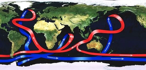
Global ocean circulation. Satellite image of the Earth from space with a map of ocean circulation. Ocean currents flow around the world due to differences in temperature and salinity. A current of warm water (red) from the Pacific Ocean travels westward on the ocean surface. As it flows, it evaporates and becomes saltier. The Gulf Stream carries the warm, salty water up along the East Coast of the United States, then towards Europe. At colder northern latitudes, the water becomes so dense that it sinks to the sea floor and travels south (blue). Disruption of the Gulf Stream from global warming could result in ice-age conditions in Europe
Science Photo Library features Science and Medical images including photos and illustrations
Media ID 6372773
© SCIENCE PHOTO LIBRARY
Atlantic Ocean Climate Change Climatological Climatology Continent Continents Conveyor Belt Current Currents Earth Observation From Space Global Warming Gulf Stream Ice Age Meteorological Meteorology Natural Hazard Pacific Ocean Salt Water Satellite Satellite Image Weather Big Chill Big Freeze Computer Artwork
EDITORS COMMENTS
This print showcases the intricate web of global ocean circulation, as seen from space. The satellite image of our Earth reveals a mesmerizing map of ocean currents that encircle the planet, driven by variations in temperature and salinity. A vibrant current of warm water, depicted in red hues, originates from the Pacific Ocean and travels westward across the ocean surface. Along its journey, this current evaporates and becomes increasingly saline. One prominent feature highlighted in this artwork is the Gulf Stream—a powerful conveyor belt that carries warm and salty water up along the East Coast of the United States before veering towards Europe. This vital flow ensures milder climates for both regions. However, an alarming consequence looms if global warming disrupts this crucial stream: ice-age conditions could grip Europe. The contrasting blue shades represent colder northern latitudes where denser water sinks to great depths before embarking on a southbound journey. This phenomenon known as thermohaline circulation plays a significant role in regulating Earth's climate system. Through this stunning illustration created by Science Photo Library, we gain a deeper appreciation for how interconnected our oceans are with weather patterns and climate dynamics worldwide. It serves as a reminder of nature's delicate balance and underscores the urgent need to protect our oceans from anthropogenic threats like climate change.
MADE IN AUSTRALIA
Safe Shipping with 30 Day Money Back Guarantee
FREE PERSONALISATION*
We are proud to offer a range of customisation features including Personalised Captions, Color Filters and Picture Zoom Tools
SECURE PAYMENTS
We happily accept a wide range of payment options so you can pay for the things you need in the way that is most convenient for you
* Options may vary by product and licensing agreement. Zoomed Pictures can be adjusted in the Cart.


