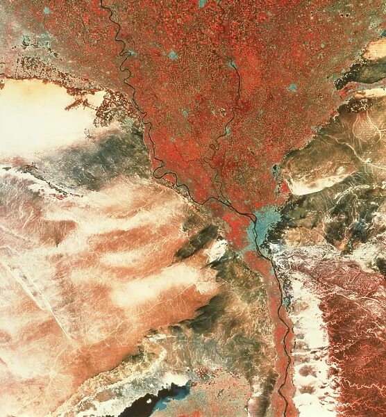
Landstat photo of Cairo & Nile delta
![]()

Wall Art and Photo Gifts from Science Photo Library
Landstat photo of Cairo & Nile delta
Landsat photograph of the city of Cairo and the Nile delta. The black thread of the river Nile can be seen surrounded by a thin strip of red vegetation which opens into the wide mouth of the delta. Cairo is visible as the light blue area at the head of the delta, just before the river forks into the Rosetta Nile (left) and the Damietta Nile (right). Light blue areas in the delta are other cities. Agriculture in the delta relies on irrigation & consists of cotton, corn & clover. Lake Qarun, lying in El Faiyum Depression, is at bottom left of the image. Extensive agriculture extends from the lake almost to the River Nile
Science Photo Library features Science and Medical images including photos and illustrations
Media ID 6357513
© MDA INFORMATION SYSTEMS/SCIENCE PHOTO LIBRARY
Cairo Capital Capitals Cities City Delta Egypt From Space Nile River Nile Urbanisation Urbanization
EDITORS COMMENTS
This stunning Landstat photo captures the breathtaking beauty of Cairo and the Nile delta from a unique perspective. The black thread-like river Nile gracefully winds its way through the image, surrounded by a narrow strip of vibrant red vegetation that gives way to the vast expanse of the delta. At the head of this natural wonder lies Cairo, depicted as a light blue area bustling with urban life. As we follow the course of the river, it splits into two branches: Rosetta Nile on the left and Damietta Nile on the right. These waterways have been vital for centuries, providing irrigation for extensive agriculture in this fertile region. From above, one can see patches of light blue scattered throughout the delta, representing other cities that thrive alongside Egypt's capital. The significance of agriculture in sustaining livelihoods becomes evident as you explore this image further. Fields stretch out across vast areas, cultivating crops such as cotton, corn, and clover that contribute to Egypt's agricultural prosperity. At bottom left lies Lake Qarun within El Faiyum Depression—a captivating oasis amidst an arid landscape. This snapshot showcases how human civilization has adapted to coexist harmoniously with nature's wonders. Through Landsat imagery like this remarkable photograph captured by Science Photo Library, we gain a deeper appreciation for our planet's diverse landscapes and marvel at mankind's ability to thrive even in challenging environments.
MADE IN AUSTRALIA
Safe Shipping with 30 Day Money Back Guarantee
FREE PERSONALISATION*
We are proud to offer a range of customisation features including Personalised Captions, Color Filters and Picture Zoom Tools
SECURE PAYMENTS
We happily accept a wide range of payment options so you can pay for the things you need in the way that is most convenient for you
* Options may vary by product and licensing agreement. Zoomed Pictures can be adjusted in the Cart.

