Home > Arts > Landscape paintings > Waterfall and river artworks > River artworks
South America, from a 16th century map

![]()
Wall Art and Photo Gifts from Science Photo Library
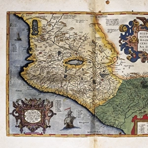
South America, from a 16th century map
South America as depicted in a map by Italian explorer Sebastian Cabot (1476-1577) in 1544. Cabot travelled to the New World with his father, John Cabot, in the services of Henry VII of England. All that remains of his personal records is his world map, of which this is a section. The River Amazon, discovered by Orellana in 1541, is shown at top. The original is kept in Paris in the Bibliotheque National. Taken from A Book of Discovery (1912) by M.B. Synge
Science Photo Library features Science and Medical images including photos and illustrations
Media ID 6349115
© SHEILA TERRY/SCIENCE PHOTO LIBRARY
1500s 16th Century Amazon Cartography Chart Continent Countries Country French Italian New World River South America World Map 1544 Bibliotheque Nationale Mappa Mundi Sebastian Cabot
MADE IN AUSTRALIA
Safe Shipping with 30 Day Money Back Guarantee
FREE PERSONALISATION*
We are proud to offer a range of customisation features including Personalised Captions, Color Filters and Picture Zoom Tools
SECURE PAYMENTS
We happily accept a wide range of payment options so you can pay for the things you need in the way that is most convenient for you
* Options may vary by product and licensing agreement. Zoomed Pictures can be adjusted in the Cart.