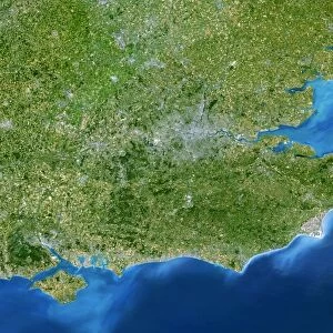
True-colour satellite image of southeast England

![]()
Wall Art and Photo Gifts from Science Photo Library
True-colour satellite image of southeast England
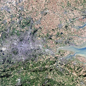
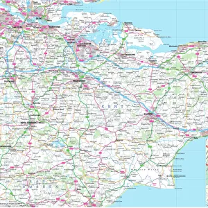
Southeast England. True-colour satellite image of southeast England, featuring the counties of Kent (at centre right), Sussex (at lower left) and Essex (at upper centre). North is at top. The River Thames flows out from the eastern suburbs of London (at left). The estuary of the River Medway is at centre. Towns visible include Southend-on- Sea (at upper centre), Gillingham (on the Medway estuary) and Eastbourne (at bottom left). Numerous ports along the coast of Kent serve the sea traffic in the English Channel (at lower right). Image taken by an American Landsat-5 satellite
Science Photo Library features Science and Medical images including photos and illustrations
Media ID 6349631
© PLANETOBSERVER/SCIENCE PHOTO LIBRARY
British Isles Earth Science Essex From Spac From Space Great Kent Sciences Sussex Thames Estuary Southeast England
EDITORS COMMENTS
This stunning true-colour satellite image captures the breathtaking beauty of southeast England. The picture showcases the picturesque counties of Kent, Sussex, and Essex in all their glory. With North at the top, the River Thames gracefully meanders through London's eastern suburbs on its way to the sea. At the center lies the estuary of the enchanting River Medway, adding a touch of tranquility to this vibrant landscape. The photo also highlights some prominent towns that dot this region. Southend-on-Sea stands out majestically near the upper center, while Gillingham finds its place along the banks of the Medway estuary. In contrast, Eastbourne graces us with its presence at bottom left. As we explore further into this image, our eyes are drawn to numerous ports along Kent's coastline catering to bustling sea traffic in one of Europe's busiest waterways - The English Channel. Captured by an American Landsat-5 satellite from space, this remarkable photograph offers a unique perspective on Southeast England's natural wonders and human settlements alike. It serves as a testament to Earth science and reminds us just how awe-inspiring our planet can be when viewed from above.
MADE IN AUSTRALIA
Safe Shipping with 30 Day Money Back Guarantee
FREE PERSONALISATION*
We are proud to offer a range of customisation features including Personalised Captions, Color Filters and Picture Zoom Tools
SECURE PAYMENTS
We happily accept a wide range of payment options so you can pay for the things you need in the way that is most convenient for you
* Options may vary by product and licensing agreement. Zoomed Pictures can be adjusted in the Cart.