Home > Europe > United Kingdom > England > Yorkshire > Stannington
land at Upperthorpe and an estate at Hollins, near Malin Bridge, in the hamlet of Stannington, 1869

![]()
Wall Art and Photo Gifts from Sheffield City Archives
land at Upperthorpe and an estate at Hollins, near Malin Bridge, in the hamlet of Stannington, 1869
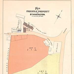
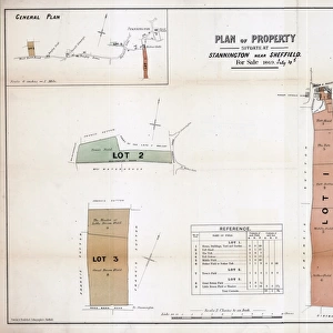
Full title: Plan of freehold land at Upperthorpe and an estate at Hollins, near Malin Bridge, in the hamlet of Stannington belonging to the trustees of the will of the late Thomas Blake, esquire.
Scale 2 chains : 1 inch.
S. F. Holmes, Surveyors, Sheffield.
Printed by Pawson and Brailsford.
Upperthorpe:
Lot 1 Four newly built dwelling houses situate at the foot of Blake Street... in the occupation of Messrs Hemingway, Townsend, Clayton and Pechy, ... these houses are very well built and finished, and offer a most eligible investment.
Lots 2 plot of building ground with a good frontage to Blake Street.
Lots 3 building plot also fronting Blake Street.
Lot 4 plot of building ground on the opposite, or north east side of Blake Street.
Lot 5 Ten freehold ground rents (the original particulars list the lessees.
Hollins:
Lot 6 Farm house, outbuildings and garden... at Hollins in the occupation of Benjamin Slack.
Lot 7 grass land known as Near Back Field.
Lot 8 grass lands known as Far Back Field.
Lot 9 land called Hollins Bottom, fronting Spooners Wheel Lane.
Lot 10 land called Middle Hollins and land called Upper Hollins, both fronting Hollins Road.
From an original at Sheffield Libraries
Sheffield City Archives and Local Studies Library has an unrivalled collection of images of Sheffield, England
Media ID 14086798
Maps Sheffield Stannington Upperthorpe Yorkshire Blake Street Hollins Road Wheel Lane
FEATURES IN THESE COLLECTIONS
> Arts
> Artists
> N
> Thomas North
> Europe
> France
> Canton
> Landes
> Europe
> United Kingdom
> England
> North Yorkshire
> Related Images
> Europe
> United Kingdom
> England
> Yorkshire
> Clayton
> Europe
> United Kingdom
> England
> Yorkshire
> Related Images
> Europe
> United Kingdom
> England
> Yorkshire
> Sheffield
> Europe
> United Kingdom
> England
> Yorkshire
> Stannington
> Europe
> United Kingdom
> England
> Yorkshire
> Street
> Europe
> United Kingdom
> England
> Yorkshire
> Well
> Maps and Charts
> Related Images
> Sheffield City Archives
> Maps and Plans
> Maps of Sheffield
> Sheffield City Archives
> Maps and Plans
> Maps of Stannington
EDITORS COMMENTS
This print from 1869 showcases the land at Upperthorpe and an estate at Hollins, near Malin Bridge, in the hamlet of Stannington. The full title reveals that this property belonged to the trustees of the will of Thomas Blake, esquire. The scale of the plan is 2 chains to 1 inch and it was surveyed by S. F. Holmes, Surveyors in Sheffield and printed by Pawson and Brailsford. The Upperthorpe section includes four newly built dwelling houses situated at the foot of Blake Street. These houses are occupied by Messrs Hemingway, Townsend, Clayton, and Pechy. Described as well-built and finished properties, they offer a highly desirable investment opportunity. Additionally, there are building plots with good frontage to Blake Street on Lots 2 and 3. Lot 4 offers a plot on the opposite side of Blake Street. Moving on to Hollins estate, Lot 6 features a farm house along with outbuildings and a garden occupied by Benjamin Slack. Lots 7 and 8 consist of grasslands known as Near Back Field and Far Back Field respectively. Lot 9 comprises land called Hollins Bottom which fronts Spooners Wheel Lane while Lots 10 include Middle Hollins and Upper Hollins lands both fronting Hollins Road. This historical document provides valuable insight into the development plans for these areas during that time period.
MADE IN AUSTRALIA
Safe Shipping with 30 Day Money Back Guarantee
FREE PERSONALISATION*
We are proud to offer a range of customisation features including Personalised Captions, Color Filters and Picture Zoom Tools
SECURE PAYMENTS
We happily accept a wide range of payment options so you can pay for the things you need in the way that is most convenient for you
* Options may vary by product and licensing agreement. Zoomed Pictures can be adjusted in the Cart.

![A map of Wm. Carrs Farm at Stanington [Stannington], 1747](/sq/716/map-wm-carrs-farm-stanington-stannington-1747-19192400.jpg.webp)