Fraud Blocker Skip to main content

Home > Maps and Charts > Related Images

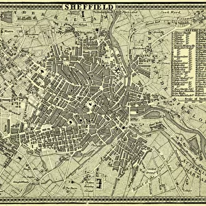
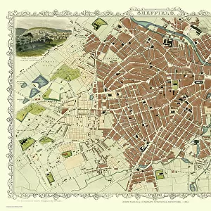
Map of the Town and Environs of Sheffield, 1864

Map of the Town and Environs of Sheffield, 1864
Sold 7
In Stock
We accept all major credit cards

Sheffield City Archives Photo Prints and Wall Art

Map of the Town and Environs of Sheffield, 1864

Scale 1 inches : 1 mile. Board and church schools have been indicated at a later date and the ecclesiastical districts have been indicated by colouring.Original at Sheffield Archives ref. SY18/1. Sheffield City Archives and Local Studies Library has an unrivalled collection of images of Sheffield, England. © Sheffield City Council

Media ID 13987657

Maps Schools

FEATURES IN THESE COLLECTIONS

> Maps and Charts > Related Images

> Sheffield City Archives > Maps and Plans > Maps of Sheffield

SECURE PAYMENTS
We happily accept a wide range of payment options so you can pay for the things you need in the way that is most convenient for you

MADE IN AUSTRALIA
Safe Shipping with 30 Day Money Back Guarantee

FREE PERSONALISATION
We are proud to offer a range of customisation including Cropping, Captions, and Filters. Zoom Cropping can be adjusted in the Basket.


EDITORS COMMENTS

This print showcases the intricate "Map of the Town and Environs of Sheffield" dating back to 1864. With a scale of 1 inch to 1 mile, this meticulously detailed map offers a fascinating glimpse into the city's past. The print highlights various landmarks such as board and church schools, which have been indicated at a later date, providing valuable insights into Sheffield's educational landscape during that era. What sets this particular map apart is its unique color-coded representation of ecclesiastical districts. Each district has been carefully colored, allowing viewers to easily identify and understand the religious divisions within Sheffield in 1864. This visual depiction adds an extra layer of historical significance to the map, shedding light on how religion played an integral role in shaping communities during that time. Preserved at Sheffield Archives under reference SY18/1, this original piece holds immense value for historians, researchers, and anyone interested in exploring Sheffield's rich heritage. It serves as a tangible link between our present-day understanding of the city and its vibrant past.


Framed Prints

Discover the rich history of Sheffield with our exquisite framed print from the Media Storehouse collection. This captivating map, hailing from 1864, showcases the Town and Environs of Sheffield, meticulously detailed at a scale of 1 inch : 1 mile. An original from Sheffield City Archives (SY18/1), this map offers a fascinating glimpse into the past, highlighting the locations of board and church schools and ecclesiastical districts, color-coded for easy identification. Bring the history of Sheffield into your home or office with this beautiful and informative framed print, a perfect addition to any room.


Photo Prints

Discover the rich history of Sheffield with our stunning Media Storehouse Photographic Print of "Map of the Town and Environs of Sheffield, 1864." This intricately detailed map, originally housed at Sheffield City Archives (SY18/1), offers a fascinating glimpse into the past. Measured at a scale of 1 inch : 1 mile, this map showcases the town of Sheffield and its surroundings as they appeared over a century ago. Notable features include board and church schools, which have been indicated at a later date, and ecclesiastical districts, distinguished by coloring. Bring the history of Sheffield into your home or office with this beautifully preserved, museum-quality print. A perfect addition to any room, it makes for an engaging conversation starter and a cherished piece of local history. Order yours today and embark on a journey through time.


Poster Prints

Introducing the latest addition to our Media Storehouse Poster Prints collection: A captivating map of Sheffield and its surroundings from 1864. This intricately detailed antique map, sourced from the Sheffield City Archives, offers a fascinating glimpse into the history of this industrial powerhouse. Scale: 1 inch : 1 mile. This map not only showcases the town's layout but also features board and church schools, indicated at a later date, and ecclesiastical districts distinguished by color. Original map held at Sheffield Archives, reference SY18/1. Bring the rich history of Sheffield into your home or office with this beautifully preserved, high-quality poster print. Perfect for history enthusiasts, educators, or anyone with an appreciation for the past. Order yours today and let the stories of Sheffield's past come alive in your space.


Jigsaw Puzzles

Discover the rich history of Sheffield with our captivating jigsaw puzzle from Media Storehouse. This intriguing puzzle features a detailed map of the town and its surroundings from 1864, as originally held in the Sheffield City Archives. With a scale of 1 inch : 1 mile, this puzzle offers an authentic representation of the town's layout during this period. Delve deeper into Sheffield's history as you piece together the locations of board and church schools, indicated at a later date, and explore the ecclesiastical districts, colorfully marked on the map. The intricate details and high-quality finish of this puzzle make it an engaging and rewarding experience for puzzle enthusiasts and history buffs alike. Bring a piece of Sheffield's past into your home and create a beautiful display with this captivating jigsaw puzzle from Media Storehouse. Original archival reference: SY18/1.

diamond
Made With High Grade Materials
thumb_up
Professional Quality Finish
package_2
Carefully Packed To Aid Safe Arrival

You May Also Like


Plan of Sheffield, 1838Plan of Sheffield, 1838
Add to Basket
A correct plan of the town of Sheffield by William Fairbank, 1771A correct plan of the town of Sheffield by William Fairbank, 1771
Add to Basket
Plan of Sheffield, 19th centPlan of Sheffield, 19th cent
Add to Basket
A plan of the intended canal from Sheffield to Tinsley by W. and J. Fairbank, 1815A plan of the intended canal from Sheffield to Tinsley by W. and J. Fairbank, 1815
Add to Basket
Map of the Rivelin Valley Estate, 1934Map of the Rivelin Valley Estate, 1934
Add to Basket
North Sheffield marked with bombing targets, c. 1940North Sheffield marked with bombing targets, c. 1940
Add to Basket
Map of SheffieldMap of Sheffield
Add to Basket
Plan of Sheffield, Yorkshire, c. 1870 - 1905Plan of Sheffield, Yorkshire, c. 1870 - 1905
Add to Basket
Map of the parish of Sheffield by W. Fairbank and Son (engraved by J. Cary), 1795Map of the parish of Sheffield by W. Fairbank and Son (engraved by J. Cary), 1795
Add to Basket
Sheffield, 1822Sheffield, 1822
Add to Basket
Old Map of Sheffield 1851 by John TallisOld Map of Sheffield 1851 by John Tallis
Add to Basket
Plan of part of the townships of Sheffield and Nether Hallam, Sheffield, c. 1826Plan of part of the townships of Sheffield and Nether Hallam, Sheffield, c. 1826
Add to Basket

Gallery Wall Inspiration

A correct plan of the town of Sheffield by William Fairbank, 1771
Norton Estate as allotted for sale, 1849
Plan of Sheffield, Yorkshire, c. 1870 - 1905
Map of the Town and Environs of Sheffield, 1864
The Duke of Norfolks estates in Brightside Bierlow, Sheffield, [mid 19th cent]
The east prospect of Sheffield in the County of York, 1745
Bacon's large scale plan of Sheffield, c.1890s
North perspective view of the town of Sheffield, c. 1737
Plan of the Furnace at Chapeltown, Sheffield, 1777
Clifford House, Psalter Lane, Sheffield and surrounding land, 1820
A map of the dams, goights and other works belonging to the Pond Forge Co, Sheffield, Yorkshire
A plan of certain premises in Pond Well Hill, Sheffield, the property of William Wilson, 1838
Plan of Thomas Rawson and Co. Pond Street Brewery, Sheffield, Yorkshire, 1832
Plan of part of the markets in Sheffield, 1827
Plan of Rockingham Street, Division Street, Rockingham Lane and Carver Street, Sheffield, 1829
Plan of part of Broom Hall Lane, Sheffield, 1830
Plan of part of the west side of the township of Sheffield, 1829
Plan shewing the antient [sic] boundary line between part of the townships of Sheffield, Ecclesall and Nether Hallam, 1834
Plan of part of the townships of Sheffield and Ecclesall Bierlow, shewing the ancient boundary line, 1835
Plan of Arundel Street, Charles Street, etc, Sheffield, c. 1829
Plan of Broomhall Mill, Sheffield, [1828]
Plan of Holt House estate, Abbeydale, Sheffield, 1823
Owlerton. Lady Burgoynes land - White House, High House, Hill Foot, Limerick Wheel, Sheffield, [1825]
Plan of Owlerton Hall estate, Sheffield [1825]
Plan of Ranmoor and Nether Green, Sheffield, 1830
Plan of the Rivelin Valley from Rivelin Mill to Hollins Bridge, c. 1814
Mousehole Forge, Rivelin Valley, Rivelin, c. 1825


© Copyright Media Storehouse, All Rights Reserved 2003 - 2024
Facebook     Pinterest     Card Payments     Reviews IO