Fraud Blocker Skip to main content

Home > Europe > United Kingdom > England > Yorkshire > Sheffield

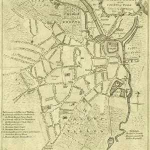
Plan of part of the west side of the township of Sheffield, 1829

Plan of part of the west side of the township of Sheffield, 1829
In Stock
We accept all major credit cards
Framed Photos
Buy from AU$119.99
Photo Prints
Buy from AU$12.99
Jigsaw Puzzles
Buy from AU$89.99
Poster Prints
Buy from AU$24.99
Canvas Prints
Buy from AU$124.99
Fine Art Prints
Buy from AU$92.53
Metal Prints
Buy from AU$43.99
Cards
Buy from AU$12.99
Home Decor
Buy from AU$24.99

Sheffield City Archives Photo Prints and Wall Art

Plan of part of the west side of the township of Sheffield, 1829

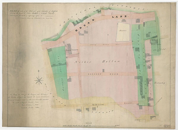
Full title: Plan of part of the west side of the township of Sheffield shewing the parts of Nether Hallam and Ecclesall Bierlow intermixed therewith and adjoining upon it.
Taken for the Surveyors of the Highways of the township of Sheffield and describes the ancient boundaries of the several townships which are coloured as hereunder described - the lands of the Sheffield township - green, Nether Hallam - red, and Ecclesall Bierlow - yellow.
Shows Broad Lane, Leavy Greave Lane, Glossop Road, Portobello, Wilkinson Street, Gell Street and Hawke Street; also shows Leavy Greave [property] and a reservoir.
Dimensions of original approx. 85 x 63 cm.
From an original at Sheffield Libraries: arc04048. Sheffield City Archives and Local Studies Library has an unrivalled collection of images of Sheffield, England. © Sheffield City Council - All Rights Reserved

Media ID 23122569

Sheffield Yorkshire

FEATURES IN THESE COLLECTIONS

> Europe > United Kingdom > England > West Yorkshire > Related Images

> Europe > United Kingdom > England > Yorkshire > Related Images

> Europe > United Kingdom > England > Yorkshire > Sheffield

> Europe > United Kingdom > England > Yorkshire > Street

> Maps and Charts > Early Maps

> Maps and Charts > Related Images

> Sheffield City Archives > Maps and Plans > Maps of Sheffield

SECURE PAYMENTS
We happily accept a wide range of payment options so you can pay for the things you need in the way that is most convenient for you

MADE IN AUSTRALIA
Safe Shipping with 30 Day Money Back Guarantee

FREE PERSONALISATION
We are proud to offer a range of customisation including Cropping, Captions, and Filters. Zoom Cropping can be adjusted in the Basket.


EDITORS COMMENTS

This print showcases a historical map titled "Plan of part of the west side of the township of Sheffield, 1829". The detailed illustration provides a fascinating glimpse into the past, specifically highlighting Nether Hallam and Ecclesall Bierlow townships intertwined with Sheffield. Commissioned by the Surveyors of the Highways in Sheffield, this map accurately depicts ancient boundaries using distinct colors to differentiate each township: green for Sheffield, red for Nether Hallam, and yellow for Ecclesall Bierlow. Notable landmarks such as Broad Lane, Leavy Greave Lane, Glossop Road, Portobello, Wilkinson Street, Gell Street, and Hawke Street are clearly marked on this comprehensive plan. The inclusion of Leavy Greave property and a reservoir adds further intrigue to this historical document. With dimensions approximating 85 x 63 cm. , it is evident that great care was taken in creating this intricate map. Preserved within Sheffield Libraries' archives (arc04048), this invaluable piece offers an opportunity to explore Yorkshire's rich history through cartography. It is important to note that while sharing information about this remarkable artifact from Sheffield City Archives is encouraged; any commercial use or association with a specific company should not be mentioned or implied.


Framed Prints

Step back in time with our exclusive Framed Print from Media Storehouse, featuring a historic plan of Sheffield's west side from 1829. This fascinating map, sourced from Sheffield City Archives, showcases the layout of Nether Hallam and Ecclesall Bierlow, providing a unique insight into the township's history. Each print is carefully framed to preserve and enhance the intricate details of this precious piece of local heritage. Add a touch of history and character to your home or office with this beautiful and informative framed print.


Photo Prints

Step back in time with Media Storehouse's exclusive range of historical photographic prints. This captivating image, titled "Plan of part of the west side of the township of Sheffield, 1829," is a rare glimpse into the past from the Sheffield City Archives. The detailed map showcases the west side of the township of Sheffield, highlighting the areas of Nether Hallam and Ecclesall Bierlow. Bring the rich history of Sheffield into your home or office with this beautiful and intriguing piece of local heritage. Order now and travel through time with every print from Media Storehouse.


Poster Prints

Step back in time with our vintage poster print from the Media Storehouse collection. This captivating image showcases a historical plan of part of the west side of the township of Sheffield, as it appeared in 1829. Discover the intricacies of Nether Hallam and Ecclesall Bierlow, beautifully preserved in this rare map from the Sheffield City Archives. Bring a piece of history into your home or office and add an authentic touch to your decor. Order now and travel back in time with every look.


Jigsaw Puzzles

Step back in time with our captivating jigsaw puzzle from Media Storehouse. This intriguing puzzle features an authentic historical plan of part of the west side of Sheffield, dating back to 1829. Originating from the Sheffield City Archives, this puzzle offers a unique glimpse into the past, showcasing the layout of Nether Hallam and Ecclesall Bierlow. Assemble this intricate puzzle to bring history to life in your home and enjoy the satisfying experience of piecing together this piece of Sheffield's rich heritage. A perfect activity for puzzle enthusiasts, history buffs, or anyone seeking a challenging and rewarding pastime.

diamond
Made With High Grade Materials
thumb_up
Professional Quality Finish
package_2
Carefully Packed To Aid Safe Arrival

You May Also Like


World War One tank, Fitzalan Square, Sheffield, 1917World War One tank, Fitzalan Square, Sheffield, 1917
Add to Basket
Political cartoon depicting Lord Rosebery in Sheffield, 19th centPolitical cartoon depicting Lord Rosebery in Sheffield, 19th cent
Add to Basket
Attercliffe Palace Theatre, Sheffield, Yorkshire, programme, c. 1951Attercliffe Palace Theatre, Sheffield, Yorkshire, programme, c. 1951
Add to Basket
Attercliffe Palace Theatre, Sheffield, Yorkshire, programme, c. 1951Attercliffe Palace Theatre, Sheffield, Yorkshire, programme, c. 1951
Add to Basket
Children at Rockingham Street Fire Station, Sheffield, Yorkshire, c. 1910Children at Rockingham Street Fire Station, Sheffield, Yorkshire, c. 1910
Add to Basket
Sheffield Flood Memorial CardSheffield Flood Memorial Card
Add to Basket
Political cartoon depicting Lord Rosebery in Sheffield, 19th centPolitical cartoon depicting Lord Rosebery in Sheffield, 19th cent
Add to Basket
Married to the wrong man by Fred Melville and showing at the Alexandra Theatre, Sheffield, Yorkshire, c. 1900Married to the wrong man by Fred Melville and showing at the Alexandra Theatre, Sheffield, Yorkshire, c. 1900
Add to Basket
Illustration from the Paris Book of Hours, 1525Illustration from the Paris Book of Hours, 1525
Add to Basket
Illustration from the Paris Book of Hours, 1525Illustration from the Paris Book of Hours, 1525
Add to Basket
General Election, Sheffield poster, 1874General Election, Sheffield poster, 1874
Add to Basket
Sale particulars for valuable and important freehold property belonging to the late William Newbould, 1852Sale particulars for valuable and important freehold property belonging to the late William Newbould, 1852
Add to Basket

Gallery Wall Inspiration

A correct plan of the town of Sheffield by William Fairbank, 1771
Norton Estate as allotted for sale, 1849
Plan of Sheffield, Yorkshire, c. 1870 - 1905
Map of the Town and Environs of Sheffield, 1864
The Duke of Norfolks estates in Brightside Bierlow, Sheffield, [mid 19th cent]
The east prospect of Sheffield in the County of York, 1745
Bacon's large scale plan of Sheffield, c.1890s
North perspective view of the town of Sheffield, c. 1737
Plan of the Furnace at Chapeltown, Sheffield, 1777
Clifford House, Psalter Lane, Sheffield and surrounding land, 1820
A map of the dams, goights and other works belonging to the Pond Forge Co, Sheffield, Yorkshire
A plan of certain premises in Pond Well Hill, Sheffield, the property of William Wilson, 1838
Plan of Thomas Rawson and Co. Pond Street Brewery, Sheffield, Yorkshire, 1832
Plan of part of the markets in Sheffield, 1827
Plan of Rockingham Street, Division Street, Rockingham Lane and Carver Street, Sheffield, 1829
Plan of part of Broom Hall Lane, Sheffield, 1830
Plan of part of the west side of the township of Sheffield, 1829
Plan shewing the antient [sic] boundary line between part of the townships of Sheffield, Ecclesall and Nether Hallam, 1834
Plan of part of the townships of Sheffield and Ecclesall Bierlow, shewing the ancient boundary line, 1835
Plan of Arundel Street, Charles Street, etc, Sheffield, c. 1829
Plan of Broomhall Mill, Sheffield, [1828]
Plan of Holt House estate, Abbeydale, Sheffield, 1823
Owlerton. Lady Burgoynes land - White House, High House, Hill Foot, Limerick Wheel, Sheffield, [1825]
Plan of Owlerton Hall estate, Sheffield [1825]
Plan of Ranmoor and Nether Green, Sheffield, 1830
Plan of the Rivelin Valley from Rivelin Mill to Hollins Bridge, c. 1814
Mousehole Forge, Rivelin Valley, Rivelin, c. 1825

Discover Our Collections


Early MapsEarly Maps
View Collection
Maps of SheffieldMaps of Sheffield
View Collection
Maps and Charts Related ImagesMaps and Charts Related Images
View Collection
Yorkshire Related ImagesYorkshire Related Images
View Collection
StreetStreet
View Collection
SheffieldSheffield
View Collection
West Yorkshire Related ImagesWest Yorkshire Related Images
View Collection


© Copyright Media Storehouse, All Rights Reserved 2003 - 2024
Facebook     Pinterest     Card Payments     Reviews IO