Home > Arts > Landscape paintings > Waterfall and river artworks > River artworks
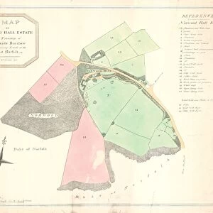
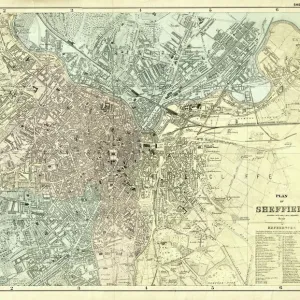
Plan of land lying between Sheffield and Ecclesfield: bounded by the River Don on the east, Barnsley Road on the west, and extending from Burnt Greave Wood and Hall Car Wood in the south, to Page Hall and Wincobank in the north, 1820

![]()
Wall Art and Photo Gifts from Sheffield City Archives
Plan of land lying between Sheffield and Ecclesfield: bounded by the River Don on the east, Barnsley Road on the west, and extending from Burnt Greave Wood and Hall Car Wood in the south, to Page Hall and Wincobank in the north, 1820
Size 28 x 28 cm.Original at Local Studies S1S
Sheffield City Archives and Local Studies Library has an unrivalled collection of images of Sheffield, England
Media ID 14048332
© Sheffield City Council
Brightside Burngreave Ecclesfield Hall Maps Wincobank
FEATURES IN THESE COLLECTIONS
> Arts
> Landscape paintings
> Waterfall and river artworks
> River artworks
> Europe
> France
> Canton
> Landes
> Maps and Charts
> Related Images
> Sheffield City Archives
> Maps and Plans
EDITORS COMMENTS
This print from the Sheffield City Archives showcases a detailed plan of land situated between Sheffield and Ecclesfield in the year 1820. Measuring at an impressive size of 28 x 28 cm, this historical document provides a fascinating glimpse into the past. The boundaries of this land are clearly defined, with the majestic River Don marking its eastern edge and Barnsley Road serving as its western limit. Stretching from Burnt Greave Wood and Hall Car Wood in the south to Page Hall and Wincobank in the north, this vast expanse holds countless stories waiting to be discovered. As we delve into this intricate map, it becomes evident that it was meticulously crafted to capture every detail of this region's geography. The names Brightside, Burngreave, Page Hall, Ecclesfield, Maps, and Wincobank stand out prominently on this print – each representing a unique facet of history within these lands. Preserved with care by Sheffield City Archives' Local Studies collection (S1S), this print offers an invaluable resource for researchers and history enthusiasts alike. It serves as a window through time, allowing us to explore how these landscapes have evolved over centuries
MADE IN AUSTRALIA
Safe Shipping with 30 Day Money Back Guarantee
FREE PERSONALISATION*
We are proud to offer a range of customisation features including Personalised Captions, Color Filters and Picture Zoom Tools
SECURE PAYMENTS
We happily accept a wide range of payment options so you can pay for the things you need in the way that is most convenient for you
* Options may vary by product and licensing agreement. Zoomed Pictures can be adjusted in the Cart.


![The Duke of Norfolks estates in Brightside Bierlow, Sheffield, [mid 19th cent]](/sq/716/duke-norfolks-estates-brightside-bierlow-20355002.jpg.webp)