Home > Arts > Portraits > Pop art gallery > Street art portraits
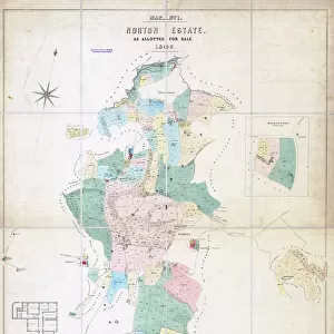
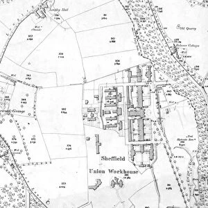
Plan of Nottingham Cliff Recreation Ground, 1897

![]()
Wall Art and Photo Gifts from Sheffield City Archives
Plan of Nottingham Cliff Recreation Ground, 1897
Image from Sheffield City Council, General Purposes and Parks Committee - Plans and Description of Parks and Recreation Grounds (Local Studies Library 352.7 SQ)
Sheffield City Archives and Local Studies Library has an unrivalled collection of images of Sheffield, England
Media ID 14047333
© Sheffield City Council
Gardens Ground Maps Parks Pitsmoor Road Street Nottingham
FEATURES IN THESE COLLECTIONS
> Arts
> Portraits
> Pop art gallery
> Street art portraits
> Maps and Charts
> Related Images
> Sheffield City Archives
> Maps and Plans
EDITORS COMMENTS
This print takes us back in time to the year 1897, offering a glimpse into the past with its detailed depiction of the "Plan of Nottingham Cliff Recreation Ground". Preserved by Sheffield City Archives, this image showcases an invaluable piece of history from the General Purposes and Parks Committee's collection. The photograph captures a meticulously drawn map that highlights every intricate detail of this cherished recreational space. Located in Pitsmoor, Nottingham Cliff Recreation Ground is showcased as a hub for leisure and community engagement. The roads and streets surrounding it are intricately illustrated, providing insight into the urban landscape at that time. As we delve deeper into this snapshot from yesteryears, we can observe how parks and gardens were thoughtfully integrated within city planning even over a century ago. This particular recreation ground appears to be an oasis amidst bustling streets, inviting residents to escape their daily routines and immerse themselves in nature's embrace. It is worth noting that this historical artifact should not be mistaken for any commercial use; rather it serves as a testament to Sheffield's commitment towards preserving its rich heritage. Through images like these, we gain appreciation for our ancestors' foresight in creating spaces where communities could come together to relax, play sports or simply find solace amidst greenery. In conclusion, this remarkable print offers us an opportunity to reflect on how public spaces have evolved over time while reminding us of the importance of cherishing our shared history.
MADE IN AUSTRALIA
Safe Shipping with 30 Day Money Back Guarantee
FREE PERSONALISATION*
We are proud to offer a range of customisation features including Personalised Captions, Color Filters and Picture Zoom Tools
SECURE PAYMENTS
We happily accept a wide range of payment options so you can pay for the things you need in the way that is most convenient for you
* Options may vary by product and licensing agreement. Zoomed Pictures can be adjusted in the Cart.


![Map of Woodthorpe Hall Farm [Holmesfield] in the parish of Dronfield, County of Derby, 1736](/sq/716/map-woodthorpe-hall-farm-holmesfield-parish-18987347.jpg.webp)