Home > STEAM Museum of the GWR > Artwork and documents > Maps & Plans
Canvas Print : GWR Network Map, c1920s


![]()
Canvas Prints from STEAM Museum
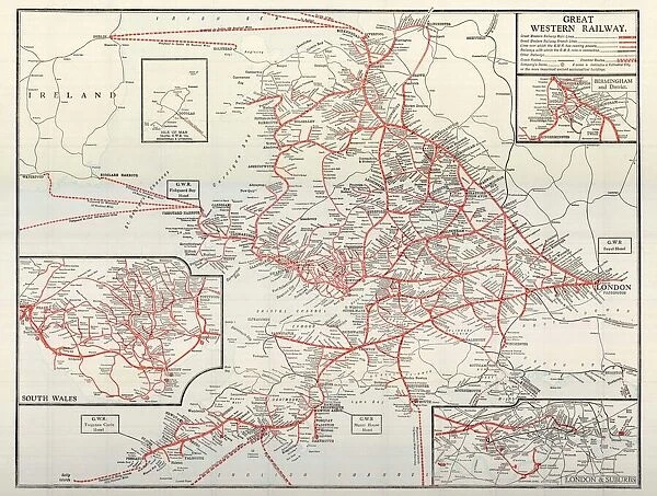
GWR Network Map, c1920s
STEAM - Museum of the Great Western Railway
Media ID 15193706
© STEAM Museum of the GWR
20"x16" (51x41cm) Canvas Print
Introducing the Media Storehouse Canvas Print of the GWR Network Map, c1920s, an intriguing piece of railway history brought to life. This stunning reproduction is taken from the archives of the STEAM Museum of the GWR and captures the comprehensive rail network of the Great Western Railway during the 1920s. Each detail is meticulously rendered on the canvas, allowing you to explore the intricacies of the map and immerse yourself in the rich heritage of the GWR. The high-quality canvas print is a perfect addition to any home or office, bringing a touch of history and character to your space. Experience the past in vibrant detail with the Media Storehouse Canvas Print of the GWR Network Map, c1920s.
Delivered stretched and ready to hang our premium quality canvas prints are made from a polyester/cotton blend canvas and stretched over a 1.25" (32mm) kiln dried knot free wood stretcher bar. Packaged in a plastic bag and secured to a cardboard insert for safe transit.
Canvas Prints add colour, depth and texture to any space. Professionally Stretched Canvas over a hidden Wooden Box Frame and Ready to Hang
Estimated Product Size is 50.8cm x 40.6cm (20" x 16")
These are individually made so all sizes are approximate
Artwork printed orientated as per the preview above, with landscape (horizontal) orientation to match the source image.
EDITORS COMMENTS
This print showcases the GWR Network Map, dating back to the 1920s. A true testament to the rich history of railway transportation, this vintage map offers a glimpse into an era when steam locomotives ruled the tracks.
With intricate details and vibrant colors, this map serves as a visual time capsule, preserving the extensive network of Great Western Railway (GWR) routes from decades ago. Each line on this meticulously crafted chart represents a lifeline connecting bustling cities, picturesque towns, and quaint villages across Britain.
As you delve into its intricacies, your eyes will trace over countless stations that once buzzed with activity; each one representing a hub of human connection and adventure. From London Paddington to Penzance in Cornwall or Swansea in Wales to Birmingham Snow Hill - these routes were arteries pumping lifeblood through the nation's veins.
Beyond its historical significance lies an aesthetic appeal that is hard to ignore. The artistry behind this map is evident in every stroke of ink and carefully placed label denoting major landmarks along each route. It is both informative and visually pleasing – a perfect blend for any enthusiast or collector.
The STEAM Museum of the GWR proudly presents this remarkable piece as part of their collection, allowing visitors to immerse themselves in an era long gone but not forgotten. Whether you are passionate about railways or simply fascinated by history's ability to transport us through time, this print invites you on a journey through Britain's past.
MADE IN AUSTRALIA
Safe Shipping with 30 Day Money Back Guarantee
FREE PERSONALISATION*
We are proud to offer a range of customisation features including Personalised Captions, Color Filters and Picture Zoom Tools
SECURE PAYMENTS
We happily accept a wide range of payment options so you can pay for the things you need in the way that is most convenient for you
* Options may vary by product and licensing agreement. Zoomed Pictures can be adjusted in the Cart.