Home > Arts > Artists > H > Franz Hogenberg
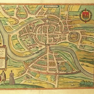
Map of Konstanz and St. Gallen from Civitates Orbis Terrarum by Georg Braun, 1541-1622 and Franz Hogenberg, 1540-1590, engraving

![]()
Wall Art and Photo Gifts from Universal Images Group (UIG)
Map of Konstanz and St. Gallen from Civitates Orbis Terrarum by Georg Braun, 1541-1622 and Franz Hogenberg, 1540-1590, engraving
Cartography, Germany and Switzerland, 16th century. Map of Konstanz and St. Gallen. From Civitates Orbis Terrarum by Georg Braun (1541-1622) and Franz Hogenberg (1540-1590), Cologne. Engraving
Universal Images Group (UIG) manages distribution for many leading specialist agencies worldwide
Media ID 9505717
© DEA / R. MERLO
16th Century Bridge Elevated View Germany Horizon Over Land Manuscript River Switzerland Townscape Konstanz
FEATURES IN THESE COLLECTIONS
> Arts
> Art Movements
> Landscapes
> Arts
> Artists
> H
> Franz Hogenberg
> Arts
> Contemporary art
> Landscapes
> Sculptures
> Arts
> Contemporary art
> Sculpture
> Landscape paintings
> Arts
> Landscape paintings
> Landscape art
> Landscape paintings
> Arts
> Landscape paintings
> Landscape art
> Arts
> Landscape paintings
> Waterfall and river artworks
> Landscape paintings
> Arts
> Landscape paintings
> Waterfall and river artworks
> River artworks
> Europe
> Germany
> Cologne (Koln)
> Universal Images Group (UIG)
> Art
> Painting, Sculpture & Prints
> Cartography
EDITORS COMMENTS
This print showcases a remarkable piece of cartographic history - the Map of Konstanz and St. Gallen from Civitates Orbis Terrarum by Georg Braun and Franz Hogenberg. Created in the 16th century, this engraving provides a fascinating glimpse into the physical geography and townscape of Germany and Switzerland during that time. The intricate details captured in this studio shot reveal an elevated view of Konstanz and St. Gallen, two prominent cities depicted with precision on this ancient map. The artistry behind this manuscript is evident as every stroke brings to life the historical landscape, complete with a flowing river that meanders through the towns. With no human representation present, one can truly appreciate the horizon over land that stretches beyond these urban centers. This horizontal composition allows viewers to immerse themselves in both the artistic beauty and historical significance encapsulated within this artwork. As we delve into its rich context, it becomes clear that this engraving serves as more than just a map; it is an invaluable artifact representing centuries-old cartography techniques. Its inclusion in Civitates Orbis Terrarum further solidifies its importance within geographical studies. This print not only offers us a visual feast but also invites contemplation about our ever-evolving world throughout history. It reminds us of how far we have come while honoring those who paved the way for modern-day mapping techniques.
MADE IN AUSTRALIA
Safe Shipping with 30 Day Money Back Guarantee
FREE PERSONALISATION*
We are proud to offer a range of customisation features including Personalised Captions, Color Filters and Picture Zoom Tools
SECURE PAYMENTS
We happily accept a wide range of payment options so you can pay for the things you need in the way that is most convenient for you
* Options may vary by product and licensing agreement. Zoomed Pictures can be adjusted in the Cart.