Home > Africa > Madagascar > Maps
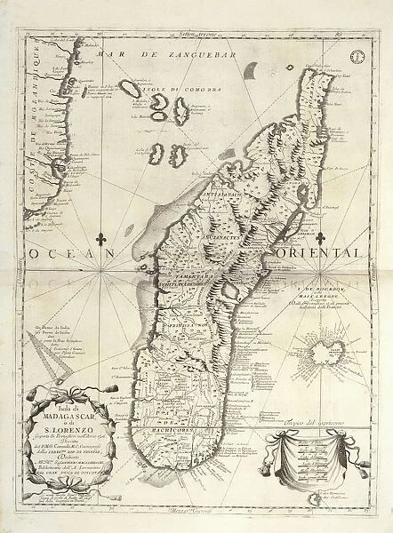
Map of Madagascar Island, from Isolario dell Atlante Veneto, Volume II, by Vincenzo Coronelli, copperplate, printed in Venice, 1696-1697
![]()

Wall Art and Photo Gifts from Universal Images Group (UIG)
Map of Madagascar Island, from Isolario dell Atlante Veneto, Volume II, by Vincenzo Coronelli, copperplate, printed in Venice, 1696-1697
Cartography, 17th century. Madagascar Island, From the Isolario dell Atlante Veneto, Volume II, by Vincenzo Coronelli, Venice 1696-1697. Copper print on paper. 61 x 45.5 cm
Universal Images Group (UIG) manages distribution for many leading specialist agencies worldwide
Media ID 9571645
© DEA PICTURE LIBRARY
17th Century Africa Complexity Copperplate Direction Guidance Indian Ocean Island Madagascar Western Script Vincenzo Coronelli
FEATURES IN THESE COLLECTIONS
> Africa
> Madagascar
> Maps
> Europe
> Italy
> Veneto
> Related Images
> Universal Images Group (UIG)
> Art
> Painting, Sculpture & Prints
> Cartography
EDITORS COMMENTS
This print showcases a remarkable piece of cartographic history - the Map of Madagascar Island from the Isolario dell Atlante Veneto, Volume II, created by Vincenzo Coronelli in Venice between 1696 and 1697. Crafted using copperplate printing techniques, this intricate map measures 61 x 45.5 cm and offers a fascinating glimpse into the world of 17th-century navigation. With its vertical orientation and Western script annotations, this map serves as both a tool for guidance and an artistic masterpiece. It provides valuable insight into the physical geography of Madagascar Island, situated in the vast Indian Ocean off Africa's eastern coast. The complexity of its illustrations highlights Coronelli's attention to detail and his dedication to accurately representing this remote island. As we admire this historical artifact, we are transported back in time to an era when maps were essential companions for travelers seeking new frontiers. This particular map not only aids in understanding Madagascar's geographical features but also sheds light on the artistry involved in creating such navigational tools. The absence of people within this image allows us to focus solely on the beauty and precision captured by Coronelli's craftsmanship. Whether used for practical purposes or admired purely for its aesthetic value, this Map of Madagascar Island is a testament to human curiosity about our planet's diverse landscapes.
MADE IN AUSTRALIA
Safe Shipping with 30 Day Money Back Guarantee
FREE PERSONALISATION*
We are proud to offer a range of customisation features including Personalised Captions, Color Filters and Picture Zoom Tools
SECURE PAYMENTS
We happily accept a wide range of payment options so you can pay for the things you need in the way that is most convenient for you
* Options may vary by product and licensing agreement. Zoomed Pictures can be adjusted in the Cart.


