Home > Europe > United Kingdom > Wales > Sculptures
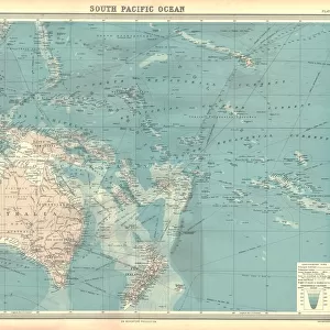
Map of South Seas, New Zealand, New Guinea, New South Wales, Society Islands by Antonio Zatta according to discoveries of James Cook, Venice 1776

![]()
Wall Art and Photo Gifts from Universal Images Group (UIG)
Map of South Seas, New Zealand, New Guinea, New South Wales, Society Islands by Antonio Zatta according to discoveries of James Cook, Venice 1776
Cartography, 18th century. Map of the South Seas (New Zealand, New Guinea, New South Wales, Society Islands) by Antonio Zatta according to the discoveries of James Cook, Venice 1776
Universal Images Group (UIG) manages distribution for many leading specialist agencies worldwide
Media ID 9503495
© DEA PICTURE LIBRARY
18th Century Exploration Island Mode Of Transport Nautical Vessel New South Wales New Zealand Sailing Boat Society Islands Transportation Western Script James Cook New Guinea
FEATURES IN THESE COLLECTIONS
> Europe
> United Kingdom
> Wales
> Maps
> Europe
> United Kingdom
> Wales
> Paintings
> Europe
> United Kingdom
> Wales
> Sculptures
> Oceania
> New Zealand
> Maps
> Universal Images Group (UIG)
> Art
> Painting, Sculpture & Prints
> Cartography
EDITORS COMMENTS
This 18th-century map print, titled "Map of South Seas, New Zealand, New Guinea, New South Wales, Society Islands" transports us back in time to the era of exploration and discovery. Created by Antonio Zatta in Venice in 1776, this meticulously detailed cartographic masterpiece showcases the vastness and beauty of the South Seas. The map is a testament to the groundbreaking expeditions led by James Cook during his voyages across these uncharted waters. It highlights key destinations such as New Zealand, New Guinea, New South Wales, and the Society Islands with precision and artistic flair. In this studio shot photograph, we see the full-length map displayed prominently against a neutral background. Its horizontal orientation allows for an immersive viewing experience that invites us to delve into its intricate details. As we gaze upon this historical artifact, our imagination takes flight on sailing boats traversing these distant seas. The map serves as both a practical tool for navigation and an exquisite work of art capturing the essence of physical geography. With no people present in this image but Western script adorning its edges like whispers from centuries past; it evokes a sense of nostalgia for times long gone. This artwork represents not only a mode of transport but also an embodiment of curiosity and human spirit's relentless pursuit to explore new frontiers. Whether you are fascinated by history or simply appreciate fine craftsmanship, this remarkable print offers a glimpse into an era when maps were gateways to unknown worlds waiting to be discovered.
MADE IN AUSTRALIA
Safe Shipping with 30 Day Money Back Guarantee
FREE PERSONALISATION*
We are proud to offer a range of customisation features including Personalised Captions, Color Filters and Picture Zoom Tools
SECURE PAYMENTS
We happily accept a wide range of payment options so you can pay for the things you need in the way that is most convenient for you
* Options may vary by product and licensing agreement. Zoomed Pictures can be adjusted in the Cart.