Home > Europe > Italy > Sicily > Related Images
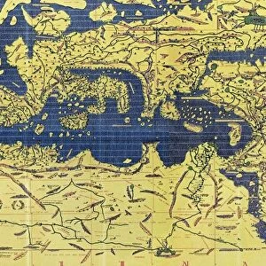
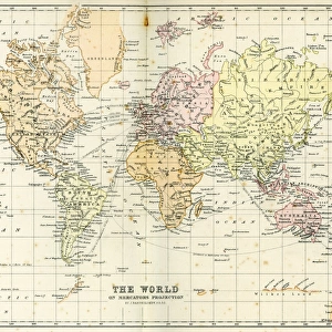
The Kitab Rudjdjar or Tabula Rogeriana, an early world map the

![]()
Wall Art and Photo Gifts from Universal Images Group (UIG)
The Kitab Rudjdjar or Tabula Rogeriana, an early world map the
The Kitab Rudjdjar or Tabula Rogeriana, an early world map the work of the Arab geographer Muhammad al-Idrisi (1100-1165) in 1154 for Roger II (1095-1154) King of Sicily from 1130. In this map, North is at the bottom
Universal Images Group (UIG) manages distribution for many leading specialist agencies worldwide
Media ID 9756865
© Universal History Archive/Universal Images Group
12th Arab Bottom Century Early Exploration Geographer Geography King Muhammad North Roger Sicily Twelfth Work World 1130 1154 Al Idrisi Tabula
FEATURES IN THESE COLLECTIONS
> Europe
> Italy
> Sicily
> Related Images
> Universal Images Group (UIG)
> History
EDITORS COMMENTS
This print showcases the remarkable Kitab Rudjdjar or Tabula Rogeriana, an early world map created by the esteemed Arab geographer Muhammad al-Idrisi in 1154. Commissioned for Roger II, the visionary King of Sicily from 1130, this masterpiece of cartography offers a unique perspective with North positioned at the bottom. Transporting us back to the twelfth century, this extraordinary map represents a pivotal moment in history when exploration and geographical understanding were flourishing. Its intricate details and precise craftsmanship reveal Idrisi's profound knowledge and dedication to his craft. The Kitab Rudjdjar or Tabula Rogeriana not only serves as a testament to Idrisi's expertise but also highlights the significant cultural exchange between Arab scholars and European rulers during that time. It symbolizes an era where boundaries were transcended through intellectual collaboration. As we delve into this awe-inspiring image, we are reminded of how maps have always been more than mere navigational tools; they are windows into our collective pasts. This particular work stands as a testament to human curiosity and our unyielding desire to explore and understand our world. Thanks to Universal Images Group (UIG), we can now appreciate this historical artifact in all its glory, allowing it to inspire future generations with its beauty and significance. Let us cherish such treasures that bridge cultures and eras while reminding us of our shared humanity.
MADE IN AUSTRALIA
Safe Shipping with 30 Day Money Back Guarantee
FREE PERSONALISATION*
We are proud to offer a range of customisation features including Personalised Captions, Color Filters and Picture Zoom Tools
SECURE PAYMENTS
We happily accept a wide range of payment options so you can pay for the things you need in the way that is most convenient for you
* Options may vary by product and licensing agreement. Zoomed Pictures can be adjusted in the Cart.