Home > Africa > Djibouti > Maps
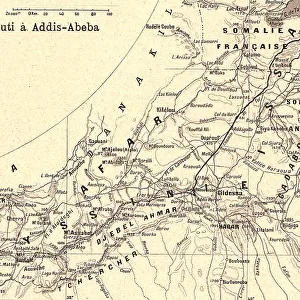
Djibouti, Relief Map With Border and Mask

![]()
Wall Art and Photo Gifts from Universal Images Group (UIG)
Djibouti, Relief Map With Border and Mask
Relief map of Djibouti (with border and mask). This image was compiled from data acquired by landsat 5 & 7 satellites combined with elevation data
Universal Images Group (UIG) manages distribution for many leading specialist agencies worldwide
Media ID 9613313
© Planet Observer/UIG
Africa Coastline Gulf Of Aden Relief Map Shore Djibouti Satellite View
FEATURES IN THESE COLLECTIONS
> Universal Images Group (UIG)
> Universal Images Group
> Satellite and Aerial
> Planet Observer 4
EDITORS COMMENTS
This print showcases the stunning relief map of Djibouti, a small yet mesmerizing country located in East Africa. The intricate details of this map were compiled using data acquired by Landsat 5 & 7 satellites, combined with elevation data. With its vibrant colors and precise cartography, this image provides a unique perspective on the physical geography of Djibouti. The relief map highlights the diverse topography of the region, depicting both land and sea features. From soaring mountain ranges to vast plains, every contour is beautifully represented in this vertical photograph. The coastline along the Gulf of Aden is particularly striking, as it gracefully curves around Djibouti's borders. What makes this image even more intriguing is that it presents an aerial view captured from a satellite. This perspective allows us to appreciate Djibouti's natural beauty without any human interference or presence visible in the frame. Whether you are fascinated by geography or simply drawn to breathtaking photography, this print offers a glimpse into Djibouti's remarkable landscape. It serves as a reminder of our planet's incredible diversity and invites us to explore new horizons through visual storytelling
MADE IN AUSTRALIA
Safe Shipping with 30 Day Money Back Guarantee
FREE PERSONALISATION*
We are proud to offer a range of customisation features including Personalised Captions, Color Filters and Picture Zoom Tools
SECURE PAYMENTS
We happily accept a wide range of payment options so you can pay for the things you need in the way that is most convenient for you
* Options may vary by product and licensing agreement. Zoomed Pictures can be adjusted in the Cart.