Home > Europe > Romania > Maps
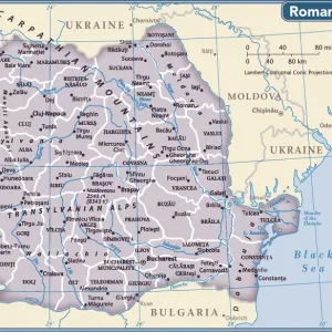
Romania, Relief Map With Border and Mask

![]()
Wall Art and Photo Gifts from Universal Images Group (UIG)
Romania, Relief Map With Border and Mask
Relief map of Romania (with border and mask). This image was compiled from data acquired by landsat 5 & 7 satellites combined with elevation data
Universal Images Group (UIG) manages distribution for many leading specialist agencies worldwide
Media ID 9612925
© Planet Observer/UIG
Balkans Black Sea Bucharest Carpathian Mountains Coastline Danube River Mountain Mountain Range Relief Map Romania Shore Snow Transylvania Satellite View
FEATURES IN THESE COLLECTIONS
> Aerial Photography
> Romania
> Europe
> Romania
> Bucharest
> Universal Images Group (UIG)
> Universal Images Group
> Satellite and Aerial
> Planet Observer 4
EDITORS COMMENTS
This stunning print captures the intricate topography of Romania, showcasing its diverse landscapes and natural beauty. The relief map, compiled from data acquired by Landsat 5 & 7 satellites combined with elevation data, offers a detailed view of this European country. The image depicts Romania's mountainous regions, highlighted by the majestic Carpathian Mountains that dominate the landscape. Snow-capped peaks stand tall against the clear blue sky, creating a breathtaking sight for any nature enthusiast. From Transylvania to Bucharest, every corner of this land is represented on this map. As we explore further into the photo print, our eyes are drawn to Romania's coastline along the Black Sea. The shoreline stretches gracefully along sandy beaches and rocky cliffs, offering a contrasting view to the rugged mountains in the north. The Danube River winds its way through Romania's heartland, cutting across plains and valleys as it flows towards the sea. This lifeline has shaped both history and geography in this region for centuries. With no people visible in this image, it allows us to focus solely on Romania's physical geography. The vibrant colors used in cartography bring life to this relief map and enhance our understanding of its terrain. Whether you are an avid traveler or simply appreciate natural wonders from afar, this print is sure to captivate your imagination with its portrayal of Romania's remarkable landscapes.
MADE IN AUSTRALIA
Safe Shipping with 30 Day Money Back Guarantee
FREE PERSONALISATION*
We are proud to offer a range of customisation features including Personalised Captions, Color Filters and Picture Zoom Tools
SECURE PAYMENTS
We happily accept a wide range of payment options so you can pay for the things you need in the way that is most convenient for you
* Options may vary by product and licensing agreement. Zoomed Pictures can be adjusted in the Cart.