Home > Animals > Mammals > Cats (Domestic) > Somali
Photographic Print : Somalia, Relief Map with Border and Mask


![]()
Photo Prints from Universal Images Group (UIG)
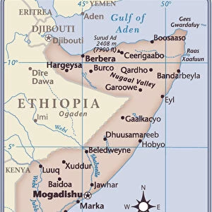
Somalia, Relief Map with Border and Mask
Relief map of Somalia (with border and mask). This image was compiled from data acquired by landsat 5 & 7 satellites combined with elevation data
Universal Images Group (UIG) manages distribution for many leading specialist agencies worldwide
Media ID 9618965
© Planet Observer/UIG
Africa Coastline Gulf Of Aden Relief Map Shore Somalia Satellite View
10"x8" (25x20cm) Photo Print
Discover the beauty and complexity of Somalia with our exquisite Media Storehouse Photographic Print of a relief map from Universal Images Group (UIG). This stunning representation of Somalia's borders and terrain is meticulously compiled from satellite data acquired by Landsat 5 and 7. With intricate detail and accurate elevation information, this print is a must-have for geography enthusiasts, world travelers, and those who appreciate the wonders of our planet. Bring the intriguing landscape of Somalia into your home or office space, and let the conversation-starting piece ignite curiosity and inspiration.
Ideal for framing, Australian made Photo Prints are produced on high-quality 270 gsm lustre photo paper which has a subtle shimmer adding a touch of elegance, designed to enhance their visual appeal.
Our Photo Prints are in a large range of sizes and are printed on Archival Quality Paper for excellent colour reproduction and longevity. They are ideal for framing (our Framed Prints use these) at a reasonable cost. Alternatives include cheaper Poster Prints and higher quality Fine Art Paper, the choice of which is largely dependant on your budget.
Estimated Image Size (if not cropped) is 18.3cm x 25.4cm (7.2" x 10")
Estimated Product Size is 20.3cm x 25.4cm (8" x 10")
These are individually made so all sizes are approximate
Artwork printed orientated as per the preview above, with portrait (vertical) orientation to match the source image.
FEATURES IN THESE COLLECTIONS
> Africa
> Somalia
> Mogadishu
> Africa
> Somalia
> Related Images
> Animals
> Mammals
> Cats (Domestic)
> Somali
> Universal Images Group (UIG)
> Universal Images Group
> Satellite and Aerial
> Planet Observer 4
EDITORS COMMENTS
This print showcases the intricate relief map of Somalia, adorned with a border and mask. The image is a result of merging data collected by the advanced Landsat 5 & 7 satellites along with elevation information. It offers an awe-inspiring glimpse into the physical geography of this African nation. The vibrant colors and vertical perspective bring to life the diverse topography that characterizes Somalia. From its stunning coastline along the Gulf of Aden to its inland regions, every contour and feature is meticulously depicted in this striking photograph. Absence of human presence allows for an uninterrupted focus on nature's artistry, as no people are visible within the frame. This emphasizes the raw beauty and untouched landscapes that define Somalia's terrain. Notably, Mogadishu, Somalia's capital city, can be identified on this relief map as it stands out amidst other geographical elements. Its significance in shaping both history and modernity becomes evident through this visual representation. Cartography enthusiasts will appreciate how this print seamlessly combines scientific satellite data with artistic flair. It serves as a testament to mankind's ability to capture Earth's wonders from above while showcasing our planet’s natural splendor
MADE IN AUSTRALIA
Safe Shipping with 30 Day Money Back Guarantee
FREE PERSONALISATION*
We are proud to offer a range of customisation features including Personalised Captions, Color Filters and Picture Zoom Tools
SECURE PAYMENTS
We happily accept a wide range of payment options so you can pay for the things you need in the way that is most convenient for you
* Options may vary by product and licensing agreement. Zoomed Pictures can be adjusted in the Cart.