Home > Europe > France > Canton > Meurthe
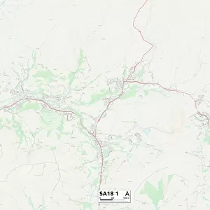
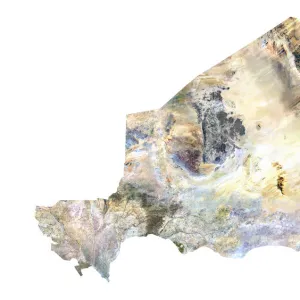
Departement of Meurthe-et-Moselle, France, Relief Map

![]()
Wall Art and Photo Gifts from Universal Images Group (UIG)
Departement of Meurthe-et-Moselle, France, Relief Map
Relief map of the departement of Meurthe-et-Moselle in Lorraine, France. It is bordered by Luxembourg and Belgium at north. This image was compiled from data acquired by LANDSAT 5 & 7 satellites combined with elevation data
Universal Images Group (UIG) manages distribution for many leading specialist agencies worldwide
Media ID 9618285
© Planet Observer
Alsace Bas Rhin Geographical Border Relief Map Satellite View
FEATURES IN THESE COLLECTIONS
> Aerial Photography
> Belgium
> Aerial Photography
> Luxembourg
> Europe
> France
> Canton
> Bas Rhin
> Europe
> France
> Canton
> Meurthe
> Europe
> France
> Canton
> Moselle
> Europe
> France
> Canton
> Rhin
> Europe
> Luxembourg
> Maps
> Universal Images Group (UIG)
> Universal Images Group
> Satellite and Aerial
> Planet Observer 6
EDITORS COMMENTS
This print showcases the stunning relief map of the Departement of Meurthe-et-Moselle in Lorraine, France. With its intricate details and vibrant colors, this image provides a fascinating glimpse into the physical geography of this region. Situated in northeastern France, Meurthe-et-Moselle shares borders with Luxembourg and Belgium to the north. Compiled from data acquired by LANDSAT 5 & 7 satellites combined with elevation data, this topographic masterpiece offers a bird's-eye view of the landscape. The undulating hills and valleys depicted on this relief map highlight the diverse terrain that characterizes Meurthe-et-Moselle. The absence of people in this photograph allows for an uninterrupted appreciation of nature's beauty. As you explore every contour and geographical border captured here, you can almost feel yourself being transported to these breathtaking landscapes. Whether you are a cartography enthusiast or simply intrigued by European geography, this print is sure to captivate your imagination. It serves as a reminder of how satellite technology has revolutionized our understanding and visualization of Earth's surface
MADE IN AUSTRALIA
Safe Shipping with 30 Day Money Back Guarantee
FREE PERSONALISATION*
We are proud to offer a range of customisation features including Personalised Captions, Color Filters and Picture Zoom Tools
SECURE PAYMENTS
We happily accept a wide range of payment options so you can pay for the things you need in the way that is most convenient for you
* Options may vary by product and licensing agreement. Zoomed Pictures can be adjusted in the Cart.