Home > Europe > France > Canton > Bas Rhin
Poster Print : Western Sahara, Relief Map


![]()
Poster Prints from Universal Images Group (UIG)
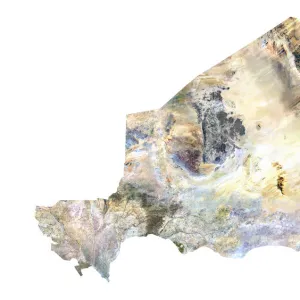
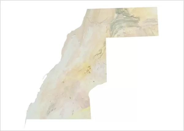
Western Sahara, Relief Map
Relief map of Western Sahara. This map was processed from elevation data
Universal Images Group (UIG) manages distribution for many leading specialist agencies worldwide
Media ID 9634169
© Planet Observer
Alsace Bas Rhin Geographical Border Relief Map Satellite View
A2 (59.4 x 42cm) Poster Print
Discover the intricacies of Western Sahara's geography with our stunning Relief Map Print from Media Storehouse and Universal Images Group (UIG). This beautifully detailed poster showcases the diverse terrain of this North African region, processed from precise elevation data. Bring a piece of the world into your home or office with this educational and visually captivating addition to your space. Order now and explore the wonders of Western Sahara in a whole new light.
Premium quality poster prints are printed on luxurious glossy or matte 270 gsm paper. Our meticulously crafted poster prints offer an affordable option for decorating any space, making them ideal for living rooms, bedrooms, offices and beyond. To ensure your poster arrives in good condition, we roll and send them in strong mailing tubes.
Poster prints are budget friendly enlarged prints in standard poster paper sizes (A0, A1, A2, A3 etc). Whilst poster paper is sometimes thinner and less durable than our other paper types, they are still ok for framing and should last many years. Our Archival Quality Photo Prints and Fine Art Paper Prints are printed on higher quality paper and the choice of which largely depends on your budget.
Estimated Product Size is 59.6cm x 42.6cm (23.5" x 16.8")
These are individually made so all sizes are approximate
Artwork printed orientated as per the preview above, with landscape (horizontal) or portrait (vertical) orientation to match the source image.
FEATURES IN THESE COLLECTIONS
> Africa
> Western Sahara
> Maps
> Africa
> Western Sahara
> Related Images
> Europe
> France
> Canton
> Bas Rhin
> Europe
> France
> Canton
> Rhin
> Universal Images Group (UIG)
> Universal Images Group
> Satellite and Aerial
> Planet Observer 6
EDITORS COMMENTS
This print showcases the intricate details of a relief map of Western Sahara, offering a unique perspective on this fascinating region. Processed from elevation data, the map beautifully captures the topography and physical geography of Western Sahara. The vibrant colors and precise cartography make it an excellent tool for studying and understanding the landforms that shape this part of Africa. Taken in Alsace, France by Universal Images Group (UIG), this vertical photograph highlights their exceptional photography skills. With no people present in the frame, all attention is drawn to the relief map itself, allowing viewers to immerse themselves in its intricacies. The satellite view adds another layer of depth to this image as it enables us to appreciate how geographical borders are defined within Western Sahara's vast expanse. The outdoors setting further enhances our connection with nature and reminds us of the importance of preserving such remarkable landscapes. It is worth noting that this caption does not mention any commercial use or affiliation with a specific company but focuses solely on appreciating the beauty and educational value offered by this particular print from Universal Images Group (UIG). Whether you are an enthusiast seeking knowledge about Western Sahara or simply captivated by maps and topography, this stunning image will undoubtedly leave you awe-inspired.
MADE IN AUSTRALIA
Safe Shipping with 30 Day Money Back Guarantee
FREE PERSONALISATION*
We are proud to offer a range of customisation features including Personalised Captions, Color Filters and Picture Zoom Tools
SECURE PAYMENTS
We happily accept a wide range of payment options so you can pay for the things you need in the way that is most convenient for you
* Options may vary by product and licensing agreement. Zoomed Pictures can be adjusted in the Cart.