Home > Europe > United Kingdom > England > Sussex > Angmering
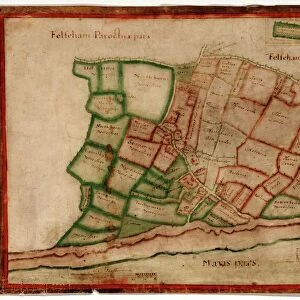
Angmering Tithe Map, 1838-39

![]()
Wall Art and Photo Gifts from West Sussex County Council
Angmering Tithe Map, 1838-39
By Henry Salter, Arundel. 26.6 in. to 1 m. Original map size 138in. × 81in.
Tithe Award Map Collection
West Sussex Record Office Ref No: TD/W3
West Sussex County Council Record Office contains a fascinating history of the county of West Sussex, England
Media ID 7914393
© West Sussex County Council - All Rights Reserved
FEATURES IN THESE COLLECTIONS
> Europe
> United Kingdom
> England
> Sussex
> Angmering
> Europe
> United Kingdom
> England
> Sussex
> Arundel
> Europe
> United Kingdom
> England
> West Sussex
> Arundel
> Maps and Charts
> Early Maps
> West Sussex County Council
> West Sussex Record Office
> Tithe Award Maps, 1808-1859
EDITORS COMMENTS
This print showcases the Angmering Tithe Map, meticulously created by Henry Salter in 1838-39. The map, which measures an impressive 26.6 inches to 1 meter, holds great historical significance as it provides a detailed representation of the land and properties within Angmering during that era. Its original size spans an astonishing 138 inches by 81 inches. Preserved within the esteemed Tithe Award Map Collection at West Sussex Record Office, this remarkable piece offers a fascinating glimpse into the past. It serves as a valuable resource for researchers, historians, and anyone curious about the evolution of this picturesque region in West Sussex. The Angmering Tithe Map is not just another commercial product; rather, it stands as a testament to the meticulous craftsmanship and dedication of its creator. This particular print does justice to Salter's work by capturing every intricate detail with utmost clarity and precision. As we delve into this slice of history through our lens, let us appreciate how such maps have played an integral role in documenting land ownership patterns and agricultural practices from centuries ago. The West Sussex County Council takes pride in preserving these invaluable artifacts for future generations to explore and learn from – reminding us all of our rich heritage rooted deep within these lands.
MADE IN AUSTRALIA
Safe Shipping with 30 Day Money Back Guarantee
FREE PERSONALISATION*
We are proud to offer a range of customisation features including Personalised Captions, Color Filters and Picture Zoom Tools
SECURE PAYMENTS
We happily accept a wide range of payment options so you can pay for the things you need in the way that is most convenient for you
* Options may vary by product and licensing agreement. Zoomed Pictures can be adjusted in the Cart.