Home > Europe > United Kingdom > England > Sussex > Ferring
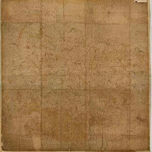
Ferring tithe map, 1837

![]()
Wall Art and Photo Gifts from West Sussex County Council
Ferring tithe map, 1837
By Henry Salter. 26.6 in. to 1 m. Part I, 41 × 28; Part II, 41 × 28 (photographs)
Tithe Award Map Collection
West Sussex Record Office Ref No: TD/W56
West Sussex County Council Record Office contains a fascinating history of the county of West Sussex, England
Media ID 10716327
© West Sussex County Council - All Rights Reserved
1830s 19th Century Historical Mapping South Of England
FEATURES IN THESE COLLECTIONS
> Europe
> United Kingdom
> England
> Maps
> Europe
> United Kingdom
> England
> Sussex
> Ferring
> Europe
> United Kingdom
> England
> West Sussex
> Related Images
> Maps and Charts
> Early Maps
> West Sussex County Council
> West Sussex Record Office
> Tithe Award Maps, 1808-1859
EDITORS COMMENTS
This print showcases the Ferring tithe map, a remarkable piece of historical mapping from 1837. Created by Henry Salter, this meticulously detailed map provides a fascinating glimpse into the past and offers valuable insights into land ownership and usage during the 19th century in southern England. Measuring an impressive 26.6 inches to one meter, this two-part map spans an area of 41 by 28 units. The intricate photographs beautifully capture every minute detail, allowing viewers to immerse themselves in the rich history it represents. Part of the esteemed Tithe Award Map Collection held at West Sussex Record Office, this particular artifact holds immense significance for researchers and history enthusiasts alike. Its reference number TD/W56 ensures its preservation for future generations to explore and study. As we delve into this snapshot of history, it is important to note that commercial use should not be associated with this image or its contents. Instead, let us appreciate the invaluable knowledge it imparts about land distribution and utilization in Ferring during a pivotal era in British history. The Ferring tithe map serves as a testament to our collective heritage while offering an opportunity for reflection on how landscapes have evolved over time. It is through such archival treasures that we can truly grasp the profound impact of our ancestors' actions on shaping our present-day surroundings.
MADE IN AUSTRALIA
Safe Shipping with 30 Day Money Back Guarantee
FREE PERSONALISATION*
We are proud to offer a range of customisation features including Personalised Captions, Color Filters and Picture Zoom Tools
SECURE PAYMENTS
We happily accept a wide range of payment options so you can pay for the things you need in the way that is most convenient for you
* Options may vary by product and licensing agreement. Zoomed Pictures can be adjusted in the Cart.