
Maps Collection (page 6)
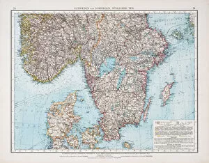
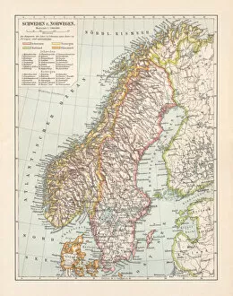
Norway is a country located in Northern Europe, bordered by Sweden, Finland and Russia
320 items


All Professionally Made to Order for Quick Shipping
-
Maps Collection
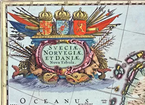
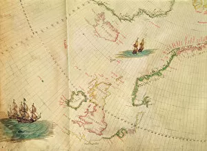
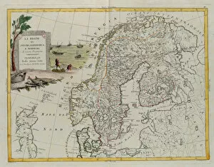
Norway is a country located in Northern Europe, bordered by Sweden, Finland and Russia. Norway is known for its stunning natural beauty and its long coastline and has a variety of terrain including mountains, fjords, glaciers and islands. Maps of Norway Europe are available to help travelers explore this beautiful country. These maps show the major cities and towns as well as roads, waterways and other points of interest such as national parks, ski resorts and museums. They also provide information about the climate in different regions so visitors can plan their trips accordingly. With these maps in hand, travelers can easily navigate their way around this fascinating country while taking in all that it has to offer.
+
Our beautiful pictures are available as Framed Prints, Photos, Wall Art and Photo Gifts
The Maps of Norway Europe collection from Media Storehouse is a stunning assortment of wall art and framed prints that showcase the beauty and diversity of Norway's landscape. Our collection features a variety of maps, including topographical maps, road maps, and historical maps that provide an in-depth look at the country's geography. Each print is carefully crafted to capture the intricate details and unique characteristics of Norway's terrain. From its rugged mountains to its picturesque fjords, our collection offers a glimpse into one of Europe's most breathtaking destinations. Whether you're looking for artwork to decorate your home or office or searching for a gift for someone who loves travel or geography, the Maps of Norway Europe collection has something for everyone. With high-quality printing techniques and durable framing options available, these prints are sure to be treasured for years to come.
+
What are Maps of Norway Europe art prints?
Maps of Norway Europe art prints are high-quality reproductions of antique and contemporary maps depicting the geography, topography, and landmarks of Norway and other European countries. These prints showcase the intricate details of each map, including borders, cities, rivers, mountains, forests, and coastlines. These maps are not only informative but also aesthetically pleasing. They make great wall decor for homes or offices with a Scandinavian or European theme. The vintage style adds a touch of nostalgia to any space while providing an educational element. We offer a wide range of Maps of Norway Europe art prints in various sizes and formats such as canvas prints or framed prints. You can choose from different styles ranging from colorful watercolor maps to black-and-white antique ones. Whether you're looking for a unique gift idea or simply want to add some character to your living space, Maps of Norway Europe art prints are an excellent choice that combines beauty and functionality.
+
What Maps of Norway Europe art prints can I buy from Media Storehouse?
We offer a wide range of Maps of Norway Europe art prints that you can purchase. These maps are available in various sizes and styles, including vintage, antique, and modern designs. You can choose from different types of maps such as topographic maps, road maps, political maps or physical maps. The collection includes detailed city plans for Oslo and other major cities in Norway. There are also regional maps that show the fjords, mountains and coastline of Norway. The prints are produced using high-quality materials to ensure they last a long time without fading or losing their vibrancy. Whether you're looking for a map to decorate your home or office space or want to gift it to someone who loves geography or history, we have something for everyone. With its extensive collection of Maps of Norway Europe art prints, you'll be sure to find the perfect one that suits your needs and preferences.
+
How do I buy Maps of Norway Europe art prints?
To buy Maps of Norway Europe art prints from Media Storehouse, you can browse our extensive collection of maps online. Simply search for "Maps of Norway" or "Europe art prints" on our website and select the print that you like. Once you have found the perfect map, add it to your cart and proceed to checkout. At checkout, you will be prompted to enter your shipping information and payment details. You can choose from a variety of payment methods including credit card, PayPal or Apple Pay. We offer high-quality art prints that are produced using state-of-the-art printing technology. Their maps are printed on premium paper stock and come in a range of sizes to suit your needs. Whether you're looking for a vintage-style map of Norway or a contemporary European cityscape, we have something for everyone. With fast shipping options available worldwide, it's easy to get your hands on beautiful Maps of Norway Europe art prints from Media Storehouse today.
+
How much do Maps of Norway Europe art prints cost?
We offer a range of Maps of Norway Europe art prints at varying prices. Our collection includes high-quality prints that are perfect for adding a touch of sophistication to any room in your home or office. The cost of our Maps of Norway Europe art prints depends on the size and type of print you choose. We have options ranging from small poster-sized prints to larger canvas prints that can make a bold statement on any wall. Our selection features maps with intricate details and vibrant colors, making them ideal for anyone who loves geography or history. Whether you're looking for a vintage-style map or something more modern, we have plenty of options to suit your taste and budget. If you're interested in purchasing one of our Maps of Norway Europe art prints, be sure to check out our website for more information about pricing and availability.
+
How will my Maps of Norway Europe art prints be delivered to me?
Your Maps of Norway Europe art prints will be delivered to you in a safe and secure manner. We take great care in packaging your order so that it arrives at your doorstep without any damage. Depending on the size of your print, we use either sturdy cardboard tubes or flat packaging to ensure that your artwork is protected during transit. We work with trusted delivery partners who have years of experience in delivering fragile items such as art prints. They are committed to ensuring that your package is handled with care and delivered to you on time. Once your order has been dispatched, you will receive an email notification containing tracking information so that you can keep track of its progress until it reaches you. If for any reason there are delays or issues with delivery, our customer service team is always available to assist and resolve any concerns promptly. We strive to provide our customers with a hassle-free shopping experience from start to finish.