Home > Maps and Charts > Abraham Ortelius
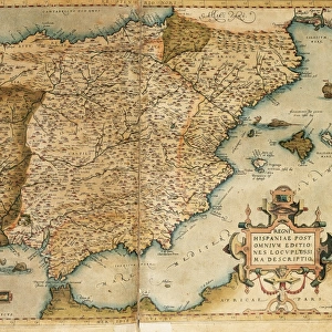
Map of Zeeland, c. 1560 (hand coloured engraving)
")
![]()
Wall Art and Photo Gifts from Fine Art Finder
Map of Zeeland, c. 1560 (hand coloured engraving)
BAL13493 Map of Zeeland, c.1560 (hand coloured engraving) by Ortelius, Abraham (1527-98); Private Collection; (add.info.: Ortelius was a mapmaker based in Antwerp; in this map he acknowledges the researches of Jacob van Deventer, geographer to Philip II of Spain; ); Flemish, out of copyright
Media ID 12695098
© www.bridgemanimages.com
Cartouche Chart Islands Mapping Poseidon Sailing Vessel Sea Monster
FEATURES IN THESE COLLECTIONS
> Fine Art Finder
> Artists
> Abraham Ortelius
> Maps and Charts
> Abraham Ortelius
EDITORS COMMENTS
This hand-coloured engraving, titled "Map of Zeeland, c. 1560" takes us on a journey back in time to the golden age of cartography. Created by the renowned mapmaker Abraham Ortelius, this exquisite piece is a testament to his skill and attention to detail. The map showcases the Dutch province of Zeeland with remarkable precision and artistry. Every contour of the coastline, every island and inlet is meticulously rendered, offering a glimpse into the geographical knowledge of that era. It is fascinating to see how Ortelius incorporated Jacob van Deventer's researches into this masterpiece, paying homage to his fellow geographer. What truly sets this print apart is its stunning embellishments. A beautifully adorned cartouche catches our eye with intricate designs and mythical creatures surrounding it. Poseidon himself seems to preside over these waters as he rides atop a sea monster while an elegant sailing vessel glides through the waves nearby. Ortelius' Map of Zeeland not only serves as a navigational tool but also as an artistic marvel that captures the spirit of exploration during this period in history. Its vibrant colours bring life to each element depicted on its surface, inviting viewers to immerse themselves in its rich details. This print from Fine Art Finder allows us access to an invaluable piece of history – one that combines both scientific accuracy and artistic beauty seamlessly within its frame.
MADE IN AUSTRALIA
Safe Shipping with 30 Day Money Back Guarantee
FREE PERSONALISATION*
We are proud to offer a range of customisation features including Personalised Captions, Color Filters and Picture Zoom Tools
SECURE PAYMENTS
We happily accept a wide range of payment options so you can pay for the things you need in the way that is most convenient for you
* Options may vary by product and licensing agreement. Zoomed Pictures can be adjusted in the Cart.