Home > Europe > United Kingdom > Scotland > Strathclyde > Glasgow
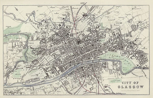
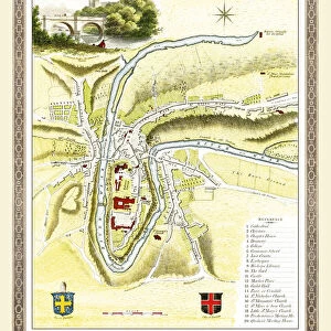
Map: City of Glasgow, drawn and engraved by G H Swanston, Edinburgh (colour litho)
![]()

Wall Art and Photo Gifts from Fine Art Finder
Map: City of Glasgow, drawn and engraved by G H Swanston, Edinburgh (colour litho)
6004702 Map: City of Glasgow, drawn and engraved by G H Swanston, Edinburgh (colour litho) by English School, (19th century); Private Collection; (add.info.: City of Glasgow, drawn and engraved by G H Swanston, Edinburgh. Illustration for A Gazetteer of the World or Dictionary of Geographical Knowledge (A Fullarton, 1858).); © Look and Learn; English, out of copyright
Media ID 23591110
© Look and Learn / Bridgeman Images
1850s Edinburgh Victoria City Of Glasgow
FEATURES IN THESE COLLECTIONS
> Arts
> Artists
> Related Images
> Europe
> United Kingdom
> Scotland
> Edinburgh
> Edinburgh
> Europe
> United Kingdom
> Scotland
> Lothian
> Edinburgh
> Europe
> United Kingdom
> Scotland
> Strathclyde
> Glasgow
> Fine Art Finder
> Artists
> English School
> Maps and Charts
> Early Maps
> Maps and Charts
> Related Images
> Maps and Charts
> World
EDITORS COMMENTS
This print showcases a meticulously detailed map of the City of Glasgow, drawn and engraved by G H Swanston in Edinburgh during the mid-19th century. The vibrant colors of this lithograph bring to life the intricate streets, landmarks, and neighborhoods that make up this bustling Scottish city. Commissioned as an illustration for A Gazetteer of the World or Dictionary of Geographical Knowledge by Fullarton in 1858, this map serves as a valuable historical artifact. It provides us with a glimpse into how Glasgow appeared during the reign of Queen Victoria, offering insights into its urban development and architectural heritage. The artistry behind G H Swanston's work is evident in every line and curve on this map. From major thoroughfares like Sauchiehall Street to iconic structures such as Glasgow Cathedral, each detail has been carefully etched onto paper with precision and skill. As we study this remarkable piece from our private collection, we are transported back in time to experience Glasgow's rich history firsthand. This image not only appeals to cartography enthusiasts but also captivates those fascinated by Victorian-era aesthetics. With its impeccable craftsmanship and historical significance, this print reminds us that maps are more than just navigational tools; they are windows into our pasts – gateways through which we can explore the stories embedded within cities like Glasgow.
MADE IN AUSTRALIA
Safe Shipping with 30 Day Money Back Guarantee
FREE PERSONALISATION*
We are proud to offer a range of customisation features including Personalised Captions, Color Filters and Picture Zoom Tools
SECURE PAYMENTS
We happily accept a wide range of payment options so you can pay for the things you need in the way that is most convenient for you
* Options may vary by product and licensing agreement. Zoomed Pictures can be adjusted in the Cart.

