Home > Maps and Charts > British Empire Maps
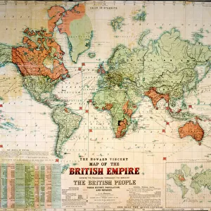
Map showing the expansion of the British Empire (colour litho)
")
![]()
Wall Art and Photo Gifts from Fine Art Finder
Map showing the expansion of the British Empire (colour litho)
3630296 Map showing the expansion of the British Empire (colour litho) by German School, (19th century); Private Collection; (add.info.: Map showing the expansion of the British Empire. Illustration from Meyers Konversations-Lexicon, c1895.); © Look and Learn
Media ID 22450944
© Look and Learn / Bridgeman Images
British Empire Colonies Encyclopedia Expansion Growth Spread
FEATURES IN THESE COLLECTIONS
> Arts
> Artists
> Related Images
> Fine Art Finder
> Artists
> English School
> Fine Art Finder
> Artists
> German School
> Maps and Charts
> British Empire Maps
> Maps and Charts
> World
EDITORS COMMENTS
This print showcases a vibrant and detailed map depicting the expansion of the British Empire during the 19th century. Created by an anonymous German School artist, this colour lithograph is part of a private collection and offers valuable insights into the historical context of colonialism. The map, originally published in Meyers Konversations-Lexicon around 1895, serves as an educational tool to understand the growth and spread of the British Empire across various continents. It highlights how Britain's influence extended far beyond its shores, with colonies scattered throughout the world. With intricate cartography and vivid colors, this image provides a visual representation of history that sparks curiosity about past global dynamics. The British Empire's vast territories are clearly marked on this map, emphasizing its dominance during that era. As we explore this artwork further, it becomes evident that it holds immense value for geography enthusiasts and history buffs alike. Its inclusion in an encyclopedia suggests its significance as a reliable source for understanding colonialism's impact on different regions worldwide. Through this print from Bridgeman Images' Fine Art Finder collection, viewers can delve into a fascinating journey through time while contemplating how empires shape our present-day world.
MADE IN AUSTRALIA
Safe Shipping with 30 Day Money Back Guarantee
FREE PERSONALISATION*
We are proud to offer a range of customisation features including Personalised Captions, Color Filters and Picture Zoom Tools
SECURE PAYMENTS
We happily accept a wide range of payment options so you can pay for the things you need in the way that is most convenient for you
* Options may vary by product and licensing agreement. Zoomed Pictures can be adjusted in the Cart.