Home > Europe > France > Paris > Maps
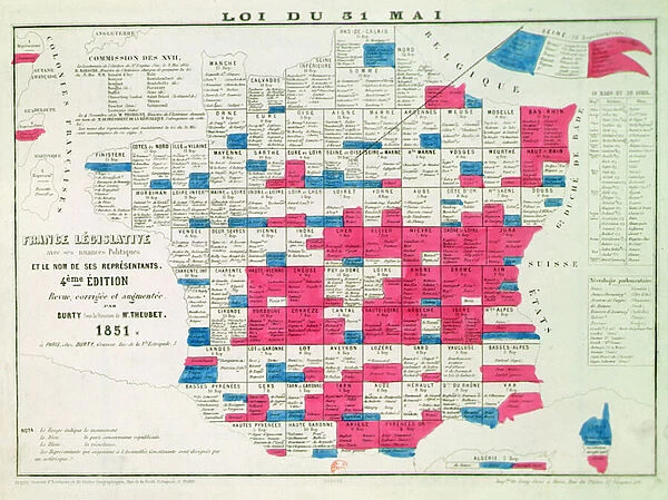
Legislative Map of France following the Universal Suffrage law voted on the 31st May 1850, printed by Burty, Paris (1851)
![]()

Wall Art and Photo Gifts from Fine Art Finder
Legislative Map of France following the Universal Suffrage law voted on the 31st May 1850, printed by Burty, Paris (1851)
CHT291519 Legislative Map of France following the Universal Suffrage law voted on the 31st May 1850, printed by Burty, Paris (1851) by French School, (19th century); Bibliotheque Nationale, Paris, France; (add.info.: sous la direction de M. Theubet; Loi du 31 Mai 1850; France Legislative avec ses nuances politiques et le nom de ses representants; in red are represented the regions undergoing changes; in blue the regions belonging to the Republican Conservative Party; in white the resistance; the law considerably reduced the number of eligible voters, affecting poor voters the most; this copy is the fourth edition; ); © Archives Charmet
Media ID 25056720
© Archives Charmet / Bridgeman Images
Administrative Areas Districts Divisions Enfranchisement Franchise Geometric Power Region Right To Vote Rights System Voting
FEATURES IN THESE COLLECTIONS
> Europe
> France
> Paris
> Maps
> Europe
> France
> Paris
> Politics
> Fine Art Finder
> Artists
> Eric Harald Macbeth Robertson
> Fine Art Finder
> Artists
> French School
> Maps and Charts
> Related Images
EDITORS COMMENTS
This print showcases the Legislative Map of France following the historic Universal Suffrage law that was voted on the 31st of May in 1850. Printed by Burty in Paris in 1851, this artwork is a testament to the significant political changes that took place during the 19th century. The map, created under the direction of M. Theubet, vividly depicts France's intricate administrative divisions and political power dynamics. Each region is represented with its own unique nuances and shades, providing valuable insight into the country's diverse political landscape at that time. The use of orthogonal geometric shapes adds a sense of order and structure to this representation of French politics. The regions undergoing changes are highlighted in red, while those belonging to the Republican Conservative Party are depicted in blue. Areas where resistance against these changes persisted are shown in white. It is important to note that this legislative map resulted from a law that significantly reduced the number of eligible voters, disproportionately affecting those who were economically disadvantaged. This aspect highlights how enfranchisement can be influenced by various factors beyond just legal rights. This particular print is from the fourth edition and belongs to Bibliotheque Nationale in Paris, France. It serves as a powerful reminder of both historical progress and ongoing struggles for equal voting rights around the world.
MADE IN AUSTRALIA
Safe Shipping with 30 Day Money Back Guarantee
FREE PERSONALISATION*
We are proud to offer a range of customisation features including Personalised Captions, Color Filters and Picture Zoom Tools
SECURE PAYMENTS
We happily accept a wide range of payment options so you can pay for the things you need in the way that is most convenient for you
* Options may vary by product and licensing agreement. Zoomed Pictures can be adjusted in the Cart.


