Home > Europe > France > Maps
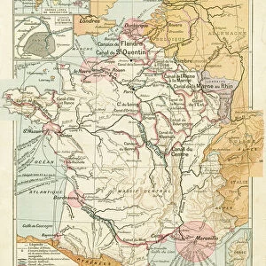
Map: France Departments. Atlas of the 1950s

![]()
Wall Art and Photo Gifts from Fine Art Finder
Map: France Departments. Atlas of the 1950s
LSE4103574 Map: France Departments. Atlas of the 1950s. by Anonymous; Private Collection; (add.info.: Map: France Departments. Atlas of the 1950s.); Photo eLeonard de Selva; out of copyright
Media ID 23316570
© Leonard de Selva / Bridgeman Images
FEATURES IN THESE COLLECTIONS
> Arts
> Artists
> Related Images
> Fine Art Finder
> Artists
> Anonymous
> Fine Art Finder
> Artists
> French School
EDITORS COMMENTS
This print showcases a vintage map titled "Map: France Departments. Atlas of the 1950s". The anonymous artist behind this masterpiece takes us on a journey back in time, offering a glimpse into the geography of France during the mid-20th century. The map itself is meticulously detailed, highlighting each department with precision and clarity. It serves as a testament to the artistry and craftsmanship involved in cartography during that era. As we examine this piece closely, we can appreciate how it captures an important historical moment when France was undergoing significant changes. Leonard de Selva skillfully captures this timeless artwork through his photography, preserving its essence for generations to come. The monochromatic tones add depth and character to the image, emphasizing its vintage charm. Whether you are an avid collector or simply fascinated by French history and geography, this print is sure to ignite your curiosity. It invites you to explore each department of France as it stood in the 1950s - from bustling cities like Paris and Marseille to picturesque regions like Provence-Alpes-Côte d'Azur or Brittany. As you gaze upon this remarkable piece, allow yourself to be transported back in time; let your imagination wander through each intricate detail of this historic atlas. This photograph not only celebrates Leonard de Selva's talent but also pays homage to an era long gone yet forever preserved within these pages.
MADE IN AUSTRALIA
Safe Shipping with 30 Day Money Back Guarantee
FREE PERSONALISATION*
We are proud to offer a range of customisation features including Personalised Captions, Color Filters and Picture Zoom Tools
SECURE PAYMENTS
We happily accept a wide range of payment options so you can pay for the things you need in the way that is most convenient for you
* Options may vary by product and licensing agreement. Zoomed Pictures can be adjusted in the Cart.