Home > Asia > China > Maps
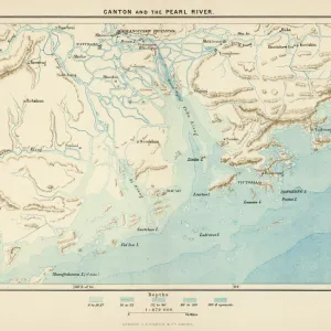
Sketch Map shewing Positions, Populations, etc, of the European Settlements in China (engraving)
")
![]()
Wall Art and Photo Gifts from Fine Art Finder
Sketch Map shewing Positions, Populations, etc, of the European Settlements in China (engraving)
1592038 Sketch Map shewing Positions, Populations, etc, of the European Settlements in China (engraving) by English School, (19th century); Private Collection; (add.info.: Sketch Map shewing Positions, Populations, etc, of the European Settlements in China. Illustration for The Illustrated London News, 24 October 1891.
English School (19th Century)); Look and Learn / Illustrated Papers Collection
Media ID 23392956
© Look and Learn / Illustrated Papers Collection / Bridgeman Images
Populations Positions Shewing Sketch Map Chineses
FEATURES IN THESE COLLECTIONS
> Fine Art Finder
> Artists
> English School
> Fine Art Finder
> Artists
> Maynard Brown
> Maps and Charts
> Related Images
EDITORS COMMENTS
This engraving, titled "Sketch Map shewing Positions, Populations, etc, of the European Settlements in China" offers a glimpse into the complex history and cultural exchange between Europe and Asia during the 19th century. Created by an English School artist for The Illustrated London News in 1891, this detailed map provides valuable insights into the distribution and demographics of European settlements across China. The intricately drawn lines depict various regions where European communities established themselves within Chinese territory. These settlements served as important hubs for trade, diplomacy, and cultural exchange between East and West. Through this visual representation, we can observe how these enclaves were strategically positioned along major waterways such as rivers or coastlines. Beyond geographical information alone, this engraving also sheds light on population dynamics within these settlements. By highlighting areas with larger populations through varying shades or symbols on the map's surface, it allows us to understand which locations thrived as vibrant centers of interaction and commerce. As we explore this historical artwork further, it becomes evident that its significance extends beyond cartography. It serves as a testament to the interconnectedness of nations during a time when global exploration was at its peak. This print is not only a visually stunning piece but also an invaluable resource for understanding the impact of European presence in China during this era of cross-cultural encounters.
MADE IN AUSTRALIA
Safe Shipping with 30 Day Money Back Guarantee
FREE PERSONALISATION*
We are proud to offer a range of customisation features including Personalised Captions, Color Filters and Picture Zoom Tools
SECURE PAYMENTS
We happily accept a wide range of payment options so you can pay for the things you need in the way that is most convenient for you
* Options may vary by product and licensing agreement. Zoomed Pictures can be adjusted in the Cart.