Home > Africa > Sudan > Maps
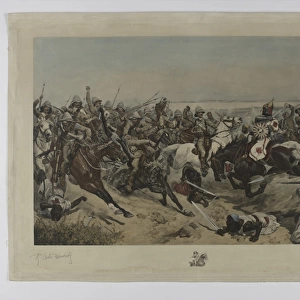
Map of the Eastern Soudan, showing the Route from Souakim to Berber (engraving)
")
![]()
Wall Art and Photo Gifts from Fine Art Finder
Map of the Eastern Soudan, showing the Route from Souakim to Berber (engraving)
1590963 Map of the Eastern Soudan, showing the Route from Souakim to Berber (engraving) by English School, (19th century); Private Collection; (add.info.: Map of the Eastern Soudan, showing the Route from Souakim to Berber. Illustration for The Illustrated London News, 14 February 1885.
English School (19th Century)); Look and Learn / Illustrated Papers Collection
Media ID 23070674
© Look and Learn / Illustrated Papers Collection / Bridgeman Images
Berber Khartoum Mahdist War Route Showing Souakim Suakin Bayuda Desert Sudan
FEATURES IN THESE COLLECTIONS
> Arts
> Artists
> Related Images
> Fine Art Finder
> Artists
> English School
> Fine Art Finder
> Artists
> Melton (after) Prior
> Maps and Charts
> Related Images
EDITORS COMMENTS
This print showcases a historical engraving titled "Map of the Eastern Soudan, showing the Route from Souakim to Berber". Created by an English School in the 19th century, this map provides a fascinating glimpse into the past. The intricate details and precise markings on this piece offer valuable insights into Sudan's geography during that era. The map highlights various significant locations such as Khartoum, Suakin, and Berber. It also encompasses the Bayuda Desert, which adds an element of mystery and intrigue to the composition. This particular map holds immense historical significance as it was originally published in The Illustrated London News on February 14th, 1885. As we delve deeper into its details, we are transported back to a time when Sudan was embroiled in the Mahdist War. This conflict between British forces and followers of Muhammad Ahmad profoundly impacted the region's history. By tracing the route from Souakim to Berber depicted on this map, one can gain a better understanding of how military strategies were devised during this tumultuous period. Preserved within a private collection and made available through Bridgeman Images' Fine Art Finder platform, this print offers both art enthusiasts and history buffs alike an opportunity to appreciate its beauty while unraveling layers of knowledge about Sudan's past.
MADE IN AUSTRALIA
Safe Shipping with 30 Day Money Back Guarantee
FREE PERSONALISATION*
We are proud to offer a range of customisation features including Personalised Captions, Color Filters and Picture Zoom Tools
SECURE PAYMENTS
We happily accept a wide range of payment options so you can pay for the things you need in the way that is most convenient for you
* Options may vary by product and licensing agreement. Zoomed Pictures can be adjusted in the Cart.