Home > Asia > Turkey > Related Images
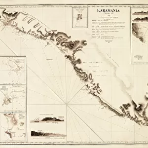
Chart of the Promontory of Boodroom with the Karabaghla Islands and the North Point of the Island of Kos ... by Francis Beaufort F.R.S. ... 1811, 1819 (engraving)
")
![]()
Wall Art and Photo Gifts from Fine Art Finder
Chart of the Promontory of Boodroom with the Karabaghla Islands and the North Point of the Island of Kos ... by Francis Beaufort F.R.S. ... 1811, 1819 (engraving)
7339475 Chart of the Promontory of Boodroom with the Karabaghla Islands and the North Point of the Island of Kos ... by Francis Beaufort F.R.S. ... 1811, 1819 (engraving) by Beaufort, Francis (fl.1819); 46x60 cm; National Maritime Museum, London, UK; (add.info.: Creator: Francis Beaufort
Explanation of placenames in Greek, Turkish and Arabic. Five views. Three inset plans: sketch of the Pasha Rock [ca. 1:15 000], sketch of the town of Kos [ca. 1:15 000], sketch of the harbour of Boodroom [ca. 1:15 000]. Admiralty chart no. 233, Hydrographic Office.); © National Maritime Museum, Greenwich, London
Media ID 38509936
© © National Maritime Museum, Greenwich, London / Bridgeman Images
FEATURES IN THESE COLLECTIONS
> Asia
> Turkey
> Related Images
> Europe
> United Kingdom
> Heritage Sites
> Maritime Greenwich
> Fine Art Finder
> Artists
> Francis Beaufort
> Fine Art Finder
> Artists
> Nicolaes Jansz (1586-1652) Visscher
EDITORS COMMENTS
This stunning engraving by Francis Beaufort F.R.S. from 1811 showcases a detailed chart of the Promontory of Boodroom with the Karabaghla Islands and the North Point of the Island of Kos. The intricate map includes explanations of place names in Greek, Turkish, and Arabic, providing a comprehensive view of this historic region.
The engraving features five views and three inset plans, including sketches of the Pasha Rock, the town of Kos, and the harbor of Boodroom. Admiralty chart no. 233 from the Hydrographic Office is referenced on this piece, highlighting its importance in maritime navigation during that time period.
The black-and-white aesthetic adds to the classic feel of this 19th-century artwork, capturing a moment in history when cartography was essential for exploration and trade across Europe. The attention to detail in Beaufort's work is evident as each element is meticulously crafted to provide an accurate representation of these coastal landmarks.
Whether you are a history enthusiast or simply appreciate fine art, this engraving is sure to captivate your imagination with its blend of beauty and functionality. Display it proudly in your home or office as a conversation starter about centuries-old mapping techniques and discoveries.
MADE IN AUSTRALIA
Safe Shipping with 30 Day Money Back Guarantee
FREE PERSONALISATION*
We are proud to offer a range of customisation features including Personalised Captions, Color Filters and Picture Zoom Tools
SECURE PAYMENTS
We happily accept a wide range of payment options so you can pay for the things you need in the way that is most convenient for you
* Options may vary by product and licensing agreement. Zoomed Pictures can be adjusted in the Cart.