Home > Europe > United Kingdom > England > London > Museums > National Maritime Museum
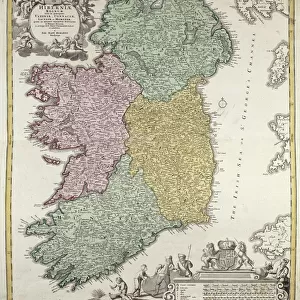
The southern tip of Peru, South America, c.1590 (hand coloured)
")
![]()
Wall Art and Photo Gifts from Fine Art Finder
The southern tip of Peru, South America, c.1590 (hand coloured)
7340745 The southern tip of Peru, South America, c.1590 (hand coloured) by Doetechum, Johannes Baptista van, the Younger (c.1560-1630); National Maritime Museum, London, UK; (add.info.: Creator: van Doetechum, Joannes van Doetechum
This chart shows two versions of the cartography of South America. The main chart is on the authority of Thomas Cavendish while the inset, with considerable inland detail, is from Spanish sources.
Sea decorated with ships and sea monsters, land has an animal and giants. Elaborate cartouche frames.); © National Maritime Museum, Greenwich, London
Media ID 38268618
© © National Maritime Museum, Greenwich, London / Bridgeman Images
Brasil Brazil Brazil Brasilian Brazil Brazilian Brazilian Brazilians Chile Chilean Chilian Chilians Latin America Peru Peru Peruvian Peruvian Peruvian Culture Peruvians Republic Of Chile
FEATURES IN THESE COLLECTIONS
> Animals
> Mammals
> Pitheciidae
> Baptista
> Arts
> Artists
> D
> Johannes Baptista van Doetechum
> Arts
> Artists
> H
> Thomas Hand
> Europe
> United Kingdom
> England
> London
> Boroughs
> Greenwich
> Europe
> United Kingdom
> England
> London
> Museums
> Greenwich Heritage Centre
> Europe
> United Kingdom
> England
> London
> Museums
> National Maritime Museum
> Europe
> United Kingdom
> England
> London
> Towns
> Greenwich
> Europe
> United Kingdom
> Heritage Sites
> Maritime Greenwich
> Europe
> United Kingdom
> Maps
> Fine Art Finder
> Artists
> Johannes Baptista van the Younger
> Fine Art Finder
> Artists
> Unknown Artist
EDITORS COMMENTS
This stunning hand-colored print of the southern tip of Peru, South America from 1590 is a true masterpiece of cartography. Created by Johannes Baptista van Doetechum, the Younger, this piece showcases two different versions of the map - one based on Thomas Cavendish's authority and another with intricate details from Spanish sources.
The sea in the chart is beautifully decorated with ships and sea monsters, while the land features an array of animals and giants. The elaborate cartouche frames add to the overall grandeur of this historical artwork.
As you gaze upon this print, you are transported back in time to the 16th century when exploration and discovery were at their peak. The detailed mapping of South America, including Brazil and Chile, provides a glimpse into how these regions were perceived centuries ago.
This print is not just a map; it is a work of art that captures the essence of exploration and adventure. It serves as a reminder of our rich history and how far we have come in understanding our world. Displaying this piece in your home will surely spark conversations about ancient civilizations and the wonders of cartography.
MADE IN AUSTRALIA
Safe Shipping with 30 Day Money Back Guarantee
FREE PERSONALISATION*
We are proud to offer a range of customisation features including Personalised Captions, Color Filters and Picture Zoom Tools
SECURE PAYMENTS
We happily accept a wide range of payment options so you can pay for the things you need in the way that is most convenient for you
* Options may vary by product and licensing agreement. Zoomed Pictures can be adjusted in the Cart.