Home > Arts > Artists > I > Indian School Indian School
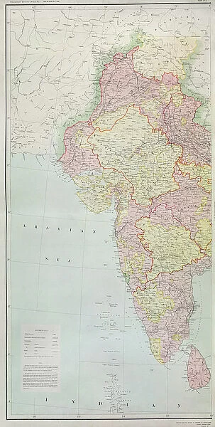
Map of India, published under the direction of Colonel H
![]()

Wall Art and Photo Gifts from Fine Art Finder
Map of India, published under the direction of Colonel H
XCF306003 Map of India, published under the direction of Colonel H.R. Thuillier, R.E. Surveyor General of India, 1877 (colour litho) by English School, (19th century); Private Collection; English, out of copyright
Media ID 18254889
© Private Collection / Bridgeman Images
Arabian Sea Baluchistan Boundaries British Empire Colonies Geographical Indian Ocean Mapping Pakistan Regions States Territories Territory
FEATURES IN THESE COLLECTIONS
> Arts
> Artists
> I
> Indian School Indian School
> Arts
> Artists
> O
> Oceanic Oceanic
> Asia
> India
> Related Images
> Asia
> Pakistan
> Related Images
> Asia
> Related Images
> Fine Art Finder
> Schools
> English School
> Maps and Charts
> British Empire Maps
> Maps and Charts
> India
> Maps and Charts
> Related Images
EDITORS COMMENTS
This print showcases a remarkable piece of history - the "Map of India" published in 1877 under the guidance of Colonel H. R. Thuillier, the esteemed Surveyor General of India. Crafted with meticulous detail and precision, this colour lithograph offers a glimpse into the cartographic mastery of the 19th century English School. The map unfolds before our eyes, revealing an expansive territory that was once part of the British Empire. It depicts not only the geographical boundaries and territories within India but also extends to regions encompassing Pakistan today. The Indian Ocean and Arabian Sea dominate its periphery, reminding us of India's strategic location as a gateway between East and West. As we delve deeper into this visual treasure trove, we encounter names like Bay of Biscal and Baluchistan, evoking curiosity about their historical significance. This map serves as both an educational tool for geography enthusiasts and a testament to colonial influence on mapping practices during that era. Preserved in a private collection, this image invites contemplation on how maps have shaped our understanding of land divisions throughout time. Its presence reminds us that even though technology has revolutionized cartography since then, these antique prints continue to hold immense value in uncovering our past.
MADE IN AUSTRALIA
Safe Shipping with 30 Day Money Back Guarantee
FREE PERSONALISATION*
We are proud to offer a range of customisation features including Personalised Captions, Color Filters and Picture Zoom Tools
SECURE PAYMENTS
We happily accept a wide range of payment options so you can pay for the things you need in the way that is most convenient for you
* Options may vary by product and licensing agreement. Zoomed Pictures can be adjusted in the Cart.

