Home > Fine Art Finder > Schools > English School
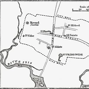
Map of Oxford, England, 12th to 13th century, from A Short History of the English

![]()
Wall Art and Photo Gifts from Fine Art Finder
Map of Oxford, England, 12th to 13th century, from A Short History of the English
KW392538 Map of Oxford, England, 12th to 13th century, from A Short History of the English People by J. R. Green, published 1893 (litho) by English School, (19th century); Private Collection; Ken Welsh; English, out of copyright
Media ID 12871972
© www.bridgemanimages.com
EDITORS COMMENTS
This print takes us back in time to the 12th and 13th centuries, as we explore a meticulously detailed map of Oxford, England. A true treasure from J. R. Green's renowned publication "A Short History of the English People" this lithograph captures the essence of medieval cartography. Every inch of this map is filled with historical significance, offering a glimpse into the city's rich past. The intricate streets wind their way through the illustration, revealing a bustling urban center that has evolved over centuries. As our eyes trace along these ancient pathways, we can almost imagine ourselves walking through history. The River Isis (known today as the Thames) gracefully meanders through Oxford, adding an enchanting touch to this visual masterpiece. Its presence reminds us of how waterways have always played a crucial role in shaping cities and fostering trade and communication. This print not only showcases exceptional craftsmanship but also serves as a valuable resource for historians and enthusiasts alike. It allows us to study and appreciate the architectural evolution of one of England's most iconic cities. As we delve into every minute detail captured on this map – from its buildings to its bridges – we are transported back in time, immersing ourselves in Oxford's vibrant past. This extraordinary piece invites us to marvel at how much has changed while recognizing that some elements still endure within this historic cityscape.
MADE IN AUSTRALIA
Safe Shipping with 30 Day Money Back Guarantee
FREE PERSONALISATION*
We are proud to offer a range of customisation features including Personalised Captions, Color Filters and Picture Zoom Tools
SECURE PAYMENTS
We happily accept a wide range of payment options so you can pay for the things you need in the way that is most convenient for you
* Options may vary by product and licensing agreement. Zoomed Pictures can be adjusted in the Cart.