Home > Maps and Charts > Early Maps
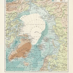
Map of nautical battle with Russian navy

![]()
Wall Art and Photo Gifts from Fine Art Storehouse
Map of nautical battle with Russian navy
1813, antiquity, archival, battle, cartography, geographical, geograph, Battle Maps and Plans, 87723369
Unleash your creativity and transform your space into a visual masterpiece!
Hemera Technologies
Media ID 18356549
© Getty Images
Antiquity Battle Geographical 1813 Geograph
FEATURES IN THESE COLLECTIONS
> Fine Art Storehouse
> History
> Battles & Wars
> Historcal Battle Maps and Plans
> Fine Art Storehouse
> Map
> Historical Maps
> Maps and Charts
> Early Maps
EDITORS COMMENTS
This print showcases a remarkable piece of history, the "Map of nautical battle with Russian navy (1813)". With its antiquity and archival value, this map takes us back to a significant moment in time. The intricate cartography and geographical details depicted on this artwork provide an insight into the naval battles that unfolded during that era. The artist's meticulous attention to detail is evident in every stroke, allowing us to visualize the intensity and magnitude of the battle. This historical artifact serves as a testament to human resilience and strategic warfare tactics employed by both sides involved. As we delve deeper into this masterpiece, we are transported back in time, witnessing the clash between mighty fleets amidst vast oceans. The sheer size of these naval forces becomes apparent as we explore each meticulously drawn ship sailing through treacherous waters. This extraordinary work from Hemera Technologies captures not only the essence of battle but also highlights the significance of maps as vital tools for military planning. It reminds us how crucial accurate geographical information was for commanders during those times. Whether you are an enthusiast fascinated by historical events or simply appreciate fine art, this print will undoubtedly captivate your imagination. Displaying it proudly will not only add elegance to any space but also serve as a constant reminder of our rich maritime heritage.
MADE IN AUSTRALIA
Safe Shipping with 30 Day Money Back Guarantee
FREE PERSONALISATION*
We are proud to offer a range of customisation features including Personalised Captions, Color Filters and Picture Zoom Tools
SECURE PAYMENTS
We happily accept a wide range of payment options so you can pay for the things you need in the way that is most convenient for you
* Options may vary by product and licensing agreement. Zoomed Pictures can be adjusted in the Cart.