Home > Europe > France > Paris > Maps
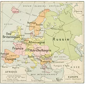
Europe map 1887

![]()
Wall Art and Photo Gifts from Fine Art Storehouse
Europe map 1887
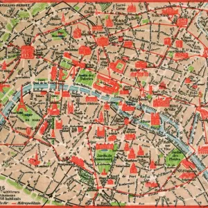
Map from La Premiere Annee de Geographie par P. Foncin - Paris 1887
Unleash your creativity and transform your space into a visual masterpiece!
THEPALMER
Media ID 19834467
© 2014 Roberto Adrian Photography
FEATURES IN THESE COLLECTIONS
> Europe
> France
> Paris
> Maps
> Fine Art Storehouse
> Map
> Historical Maps
> Maps and Charts
> Early Maps
EDITORS COMMENTS
This print showcases a remarkable piece of history - the Europe map from 1887. Taken from "La Premiere Annee de Geographie par P. Foncin" in Paris, this vintage map offers a glimpse into the world as it was over a century ago. The intricate details and exquisite craftsmanship of this artwork transport us back to an era when cartography was both an art form and a scientific endeavor. The Europe map, meticulously drawn by P. Foncin, presents a wealth of geographical information that reflects the political landscape of the time. From major cities to rivers and mountain ranges, every element is intricately depicted with precision and accuracy. This historical document not only serves as a valuable resource for scholars but also evokes nostalgia for those who appreciate the beauty of antique maps. Expertly captured by THEPALMER, this high-quality print allows us to admire every fine line and delicate hue present on the original map itself. The attention to detail in capturing this image ensures that viewers can fully immerse themselves in its rich historical significance. Whether you are an avid collector or simply fascinated by European history, this stunning print is sure to be an excellent addition to any space. Let it transport you back in time as you explore the vast lands and borders that shaped our continent over a century ago.
MADE IN AUSTRALIA
Safe Shipping with 30 Day Money Back Guarantee
FREE PERSONALISATION*
We are proud to offer a range of customisation features including Personalised Captions, Color Filters and Picture Zoom Tools
SECURE PAYMENTS
We happily accept a wide range of payment options so you can pay for the things you need in the way that is most convenient for you
* Options may vary by product and licensing agreement. Zoomed Pictures can be adjusted in the Cart.