Home > Europe > United Kingdom > England > Maps
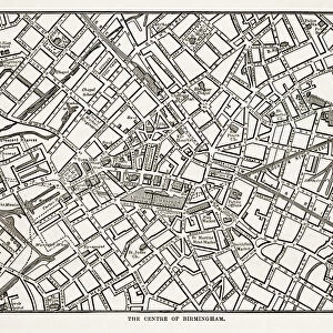
Map of Birmingham and Neighborhoods, England Victorian Engraving, 1840

![]()
Wall Art and Photo Gifts from Fine Art Storehouse
Map of Birmingham and Neighborhoods, England Victorian Engraving, 1840
Very Rare, Beautifully Illustrated Antique Engraving of Map of Birmingham and Neighborhoods, England Victorian Engraving, 1840. Source: Original edition from my own archives. Copyright has expired on this artwork. Digitally restored
Unleash your creativity and transform your space into a visual masterpiece!
bauhaus1000
Media ID 14549493
© This content is subject to copyright
FEATURES IN THESE COLLECTIONS
> Europe
> United Kingdom
> England
> Birmingham
> Related Images
> Europe
> United Kingdom
> England
> Maps
> Fine Art Storehouse
> Map
> Historical Maps
> Maps and Charts
> Early Maps
EDITORS COMMENTS
This exquisite print captures the essence of Birmingham in the Victorian era, taking us back to a time when this bustling city was rapidly transforming into an industrial powerhouse. The Map of Birmingham and Neighborhoods, England Victorian Engraving, 1840 is a true gem from my personal archives - a rare find that showcases the intricate beauty of antique engravings. As we gaze upon this meticulously illustrated map, we are transported to the streets and neighborhoods of old Birmingham. Every detail has been lovingly restored through digital enhancement, allowing us to appreciate the craftsmanship and artistry that went into creating this historical masterpiece. The landmarks depicted on this map serve as reminders of Birmingham's rich heritage. From iconic buildings such as St Philip's Cathedral and Aston Hall to bustling markets and vibrant neighborhoods, each element tells a story about the city's past. This print not only offers aesthetic pleasure but also serves as a valuable resource for historians and enthusiasts alike. It provides insight into how Birmingham evolved during the 1800s - an era marked by rapid urbanization and industrial growth. With its faded hues and delicate lines, this artwork evokes nostalgia for a bygone era while reminding us of our connection to history. It stands as a testament to both human ingenuity and artistic excellence – capturing the spirit of Victorian England in all its glory.
MADE IN AUSTRALIA
Safe Shipping with 30 Day Money Back Guarantee
FREE PERSONALISATION*
We are proud to offer a range of customisation features including Personalised Captions, Color Filters and Picture Zoom Tools
SECURE PAYMENTS
We happily accept a wide range of payment options so you can pay for the things you need in the way that is most convenient for you
* Options may vary by product and licensing agreement. Zoomed Pictures can be adjusted in the Cart.