Home > North America > United States of America > New York > New York > Maps
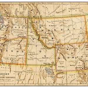
Map of Colorado and western territories 1883

![]()
Wall Art and Photo Gifts from Fine Art Storehouse
Map of Colorado and western territories 1883
The Eclectic Elementary Geography by Van Antwerp, Bragg & C0 / Cincinnati -New York 1883
Unleash your creativity and transform your space into a visual masterpiece!
THEPALMER
Media ID 18357197
FEATURES IN THESE COLLECTIONS
> Fine Art Storehouse
> Map
> Historical Maps
> Maps and Charts
> Early Maps
> North America
> United States of America
> New York
> New York
> Maps
EDITORS COMMENTS
In this print titled "Map of Colorado and western territories 1883" we are transported back in time to the late 19th century. The map, originally featured in "The Eclectic Elementary Geography" by Van Antwerp, Bragg & Co. , takes us on a visual journey through the vast expanses of Colorado and its neighboring western territories. With intricate details and vibrant colors, this piece offers a glimpse into the historical landscape of the American West during an era of exploration and expansion. It showcases not only the geographical features but also highlights important towns, rivers, mountain ranges, and railroads that played significant roles in shaping the region's development. As we study this remarkable artifact from 1883 with awe-inspiring curiosity, it becomes evident how much has changed over time. This map serves as a testament to human ingenuity and perseverance as settlers ventured westward seeking new opportunities amidst rugged terrain. "The Map of Colorado and western territories 1883" is more than just a cartographic representation; it encapsulates an entire chapter in American history. Its presence reminds us of our roots while igniting a sense of adventure within us all. Whether displayed proudly on your wall or used for educational purposes, this print by THEPALMER from Fine Art Storehouse allows you to immerse yourself in an era long gone yet forever preserved through artistry.
MADE IN AUSTRALIA
Safe Shipping with 30 Day Money Back Guarantee
FREE PERSONALISATION*
We are proud to offer a range of customisation features including Personalised Captions, Color Filters and Picture Zoom Tools
SECURE PAYMENTS
We happily accept a wide range of payment options so you can pay for the things you need in the way that is most convenient for you
* Options may vary by product and licensing agreement. Zoomed Pictures can be adjusted in the Cart.