Home > North America > United States of America > New York > New York > Maps
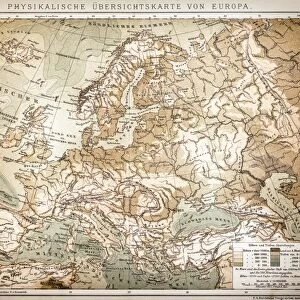
Map of Europe 1876

![]()
Wall Art and Photo Gifts from Fine Art Storehouse
Map of Europe 1876
Maurys Geographical Series - The Word we live in by M.F. Maury LLD - New York and Baltimore 1876
Unleash your creativity and transform your space into a visual masterpiece!
THEPALMER
Media ID 18357159
FEATURES IN THESE COLLECTIONS
> Europe
> Related Images
> Fine Art Storehouse
> Map
> Historical Maps
> Maps and Charts
> Early Maps
> North America
> United States of America
> New York
> New York
> Maps
EDITORS COMMENTS
This print showcases a remarkable piece of history, the "Map of Europe 1876" from Maurys Geographical Series - The World we live in by M. F. Maury LLD. Created in New York and Baltimore in the year 1876, this map offers a fascinating glimpse into the geopolitical landscape of Europe during that era. The intricate details and exquisite craftsmanship captured in this print transport us back to a time when cartography was both an art form and a scientific endeavor. Every line, contour, and label on this map tells a story about the nations, borders, and cities that shaped Europe's past. As we gaze upon this historical artifact, our imagination takes flight as we envision explorers poring over its surface with quill pens and magnifying glasses. It serves as a reminder of how far our understanding of geography has come since then. "The Map of Europe 1876" is not just an artistic representation but also an invaluable educational tool for those interested in European history or simply curious about how boundaries have evolved over time. Its presence on display adds depth to any space while inviting viewers to embark on their own journey through time. Expertly reproduced by THEPALMER for Fine Art Storehouse, this print preserves every intricate detail with utmost precision. Whether displayed at home or within educational institutions or libraries, it sparks curiosity and invites exploration into the rich tapestry of European history like never before.
MADE IN AUSTRALIA
Safe Shipping with 30 Day Money Back Guarantee
FREE PERSONALISATION*
We are proud to offer a range of customisation features including Personalised Captions, Color Filters and Picture Zoom Tools
SECURE PAYMENTS
We happily accept a wide range of payment options so you can pay for the things you need in the way that is most convenient for you
* Options may vary by product and licensing agreement. Zoomed Pictures can be adjusted in the Cart.