Home > Europe > United Kingdom > Northern Ireland > County Down > Newcastle
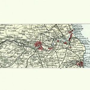
Map of Newcastle upon Tyne and surroundings, England, published 1897

![]()
Wall Art and Photo Gifts from Fine Art Storehouse
Map of Newcastle upon Tyne and surroundings, England, published 1897
Historical map of Newcastle upon Tyne and surroundings, England. Wood engraving, published in 1897
Unleash your creativity and transform your space into a visual masterpiece!
ZU_09
Media ID 18106683
FEATURES IN THESE COLLECTIONS
> Europe
> United Kingdom
> England
> Maps
> Europe
> United Kingdom
> England
> Newcastle upon Tyne
> Europe
> United Kingdom
> Northern Ireland
> County Down
> Newcastle
> Fine Art Storehouse
> Map
> Historical Maps
> Maps and Charts
> Early Maps
EDITORS COMMENTS
This historical map print takes us back to the year 1897, offering a fascinating glimpse into the city of Newcastle upon Tyne and its surrounding areas in England. Crafted through meticulous wood engraving techniques, this artwork showcases the intricate details that were painstakingly etched onto the wooden surface by an artist named ZU_09. The Map of Newcastle upon Tyne and surroundings is a true testament to the artistry and craftsmanship of cartography during that era. Every street, river, park, and landmark is meticulously depicted with precision and accuracy. The delicate lines and fine textures bring life to this vintage piece, allowing us to explore the past as if we were stepping into a time machine. As we gaze at this remarkable print, our imagination runs wild with thoughts of what life was like in late 19th century Newcastle upon Tyne. We can almost envision horse-drawn carriages traversing cobblestone streets while locals go about their daily routines amidst bustling markets and charming architecture. Whether you are an avid history enthusiast or simply appreciate beautiful works of art, this Map of Newcastle upon Tyne will transport you back in time. It serves as a reminder of how cities evolve over centuries while also preserving their unique heritage. Display it proudly on your wall or gift it to someone who shares your passion for history – either way, it will undoubtedly spark conversations about the rich tapestry that makes up our world's urban landscapes.
MADE IN AUSTRALIA
Safe Shipping with 30 Day Money Back Guarantee
FREE PERSONALISATION*
We are proud to offer a range of customisation features including Personalised Captions, Color Filters and Picture Zoom Tools
SECURE PAYMENTS
We happily accept a wide range of payment options so you can pay for the things you need in the way that is most convenient for you
* Options may vary by product and licensing agreement. Zoomed Pictures can be adjusted in the Cart.