Home > North America > United States of America > New York > New York > Maps
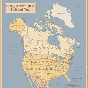
Map of North America 1876

![]()
Wall Art and Photo Gifts from Fine Art Storehouse
Map of North America 1876
Maurys Geographical Series - The Word we live in by M.F. Maury LLD - New York and Baltimore 1876
Unleash your creativity and transform your space into a visual masterpiece!
THEPALMER
Media ID 18357147
FEATURES IN THESE COLLECTIONS
> Fine Art Storehouse
> Map
> Historical Maps
> Maps and Charts
> Early Maps
> North America
> United States of America
> New York
> New York
> Maps
EDITORS COMMENTS
In this print titled "Map of North America 1876" we are transported back in time to an era when cartography was both a science and an art form. The intricate details and meticulous craftsmanship of this map, part of Maurys Geographical Series by M. F. Maury LLD, evoke a sense of wonder and curiosity about the world as it existed in the late 19th century. As we gaze upon this historical treasure, our eyes are drawn to the vibrant colors that bring life to each region depicted on the map. From the lush green forests covering vast stretches of land to the meandering rivers that carve their way through mountains and valleys, every element is meticulously portrayed with precision. The inclusion of New York and Baltimore as prominent cities reminds us of their significance during this period - bustling hubs where commerce thrived and ideas were exchanged. It serves as a reminder that even then, these cities played crucial roles in shaping not just American history but also global affairs. This print by THEPALMER captures not only a geographical representation but also provides insight into how people perceived their place in the world over a century ago. It invites us to reflect on how far we have come since then while appreciating the timeless beauty inherent in maps - windows into our pasts and gateways to understanding our present realities.
MADE IN AUSTRALIA
Safe Shipping with 30 Day Money Back Guarantee
FREE PERSONALISATION*
We are proud to offer a range of customisation features including Personalised Captions, Color Filters and Picture Zoom Tools
SECURE PAYMENTS
We happily accept a wide range of payment options so you can pay for the things you need in the way that is most convenient for you
* Options may vary by product and licensing agreement. Zoomed Pictures can be adjusted in the Cart.