Home > North America > United States of America > New York > New York > Maps
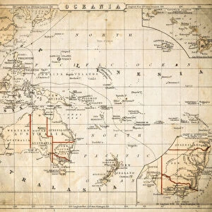
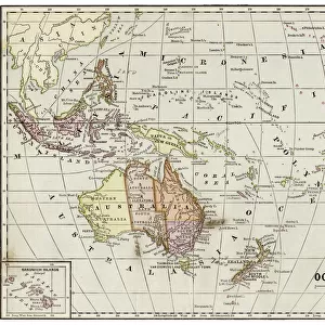
Map of Oceania 1881

![]()
Wall Art and Photo Gifts from Fine Art Storehouse
Map of Oceania 1881
Appletons American Standard Geographies - New York 1881 - d. Appleton and Company
Unleash your creativity and transform your space into a visual masterpiece!
THEPALMER
Media ID 19231209
© 2014 Roberto Adrian Photography
FEATURES IN THESE COLLECTIONS
> Fine Art Storehouse
> Map
> Historical Maps
> Maps and Charts
> Early Maps
> North America
> United States of America
> New York
> New York
> Maps
EDITORS COMMENTS
In this print titled "Map of Oceania 1881" we are transported back in time to the late 19th century, when exploration and discovery were at their peak. The map, sourced from Appletons American Standard Geographies published in New York in 1881 by d. Appleton and Company, offers a fascinating glimpse into the geographical knowledge of that era. The intricate details meticulously captured by THEPALMER take us on an enchanting journey across the vast expanse of Oceania. From Australia's sprawling deserts to New Zealand's majestic mountains, every contour is delicately etched onto this vintage masterpiece. As we explore further, our eyes are drawn to the multitude of islands scattered throughout the Pacific Ocean. Each tiny dot represents a unique culture and history waiting to be unraveled. It is as if we can almost hear the distant sounds of waves crashing against untouched shores or feel the warm tropical breeze caressing our skin. This print serves as a reminder not only of how far cartography has come but also of humanity's insatiable thirst for knowledge and adventure. It invites us to reflect upon our place within this vast world and sparks curiosity about what lies beyond its borders. With its historical significance and artistic allure, "Map of Oceania 1881" by THEPALMER becomes more than just a decorative piece; it becomes a gateway to another time—a tangible connection between past explorers' dreams and our present fascination with uncovering new horizons
MADE IN AUSTRALIA
Safe Shipping with 30 Day Money Back Guarantee
FREE PERSONALISATION*
We are proud to offer a range of customisation features including Personalised Captions, Color Filters and Picture Zoom Tools
SECURE PAYMENTS
We happily accept a wide range of payment options so you can pay for the things you need in the way that is most convenient for you
* Options may vary by product and licensing agreement. Zoomed Pictures can be adjusted in the Cart.