Home > Maps and Charts > Early Maps
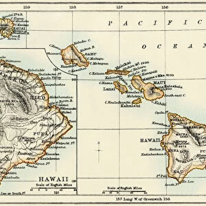
Polynesian islands map 1896

![]()
Wall Art and Photo Gifts from Fine Art Storehouse
Polynesian islands map 1896
Andres Allgemeiner Handatlas - Bielefeld und Leipzig 1896
Unleash your creativity and transform your space into a visual masterpiece!
THEPALMER
Media ID 18356809
FEATURES IN THESE COLLECTIONS
> Fine Art Storehouse
> Map
> Historical Maps
> Maps and Charts
> Early Maps
EDITORS COMMENTS
This print showcases a vintage map of the Polynesian islands, dating back to 1896. Titled "Polynesian Islands Map 1896" this exquisite piece is part of Andres Allgemeiner Handatlas - Bielefeld und Leipzig's collection. The intricate details and artistic craftsmanship displayed in this map are truly remarkable. The map takes us on a journey through time, offering a glimpse into the geographical layout of the Polynesian islands during the late 19th century. Each island is meticulously labeled, allowing viewers to explore and appreciate the vastness and diversity of this enchanting region. The warm color palette used in this print adds an element of nostalgia, evoking a sense of adventure and discovery reminiscent of explorers from that era. It serves as a reminder of how maps were once treasured possessions, guiding intrepid travelers across uncharted territories. "The Palmer" known for their expertise in curating exceptional art prints, has brought forth this historical gem for enthusiasts who appreciate both cartography and history. This particular piece offers not only aesthetic pleasure but also educational value by preserving an important snapshot from our past. Whether you're an avid collector or simply captivated by the allure of vintage maps, "Polynesian Islands Map 1896" will undoubtedly transport you to another time and place – where exploration was at its peak and curiosity knew no bounds.
MADE IN AUSTRALIA
Safe Shipping with 30 Day Money Back Guarantee
FREE PERSONALISATION*
We are proud to offer a range of customisation features including Personalised Captions, Color Filters and Picture Zoom Tools
SECURE PAYMENTS
We happily accept a wide range of payment options so you can pay for the things you need in the way that is most convenient for you
* Options may vary by product and licensing agreement. Zoomed Pictures can be adjusted in the Cart.