Home > Maps and Charts > Early Maps
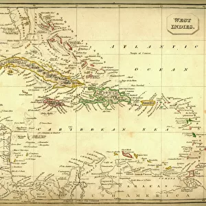
West Indies map 1892

![]()
Wall Art and Photo Gifts from Fine Art Storehouse
West Indies map 1892
Frye Grammar School Geography - 1892
Unleash your creativity and transform your space into a visual masterpiece!
THEPALMER
Media ID 14756006
© This content is subject to copyright
FEATURES IN THESE COLLECTIONS
> Fine Art Storehouse
> Map
> Historical Maps
> Maps and Charts
> Early Maps
EDITORS COMMENTS
This print showcases a vintage map of the West Indies, dating back to 1892. A relic from the Frye Grammar School Geography collection, this piece takes us on a journey through time and geography. The intricate details and vibrant colors of the map instantly transport us to an era when cartography was both an art form and a scientific endeavor. The West Indies, with its archipelago of islands scattered across the Caribbean Sea, has always held a certain allure for explorers, traders, and adventurers. This historical map allows us to delve into the region's rich history and cultural diversity. From Cuba to Jamaica, Puerto Rico to Trinidad and Tobago – each island is meticulously labeled with its name, highlighting their individual significance within this tropical paradise. As we gaze upon this remarkable artwork by THEPALMER from Fine Art Storehouse, we can't help but marvel at how much has changed since 1892. The world has evolved in countless ways; yet these islands remain timeless in their beauty and charm. Whether you are a history enthusiast or simply appreciate exquisite craftsmanship, this print serves as both an educational tool and a stunning decorative piece for any space. It invites us to explore the past while igniting our curiosity about these enchanting Caribbean gems that continue to captivate travelers today.
MADE IN AUSTRALIA
Safe Shipping with 30 Day Money Back Guarantee
FREE PERSONALISATION*
We are proud to offer a range of customisation features including Personalised Captions, Color Filters and Picture Zoom Tools
SECURE PAYMENTS
We happily accept a wide range of payment options so you can pay for the things you need in the way that is most convenient for you
* Options may vary by product and licensing agreement. Zoomed Pictures can be adjusted in the Cart.