Home > Maps and Charts > Early Maps
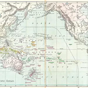
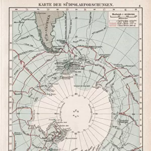
October Frequency of Winds in Relative Values Chart, Pacific Ocean, German Antique Victorian Engraving, 1896

![]()
Wall Art and Photo Gifts from Fine Art Storehouse
October Frequency of Winds in Relative Values Chart, Pacific Ocean, German Antique Victorian Engraving, 1896
Very Rare, Beautifully Illustrated Antique Engraving of October Frequency of Winds in Relative Values Chart, Pacific Ocean, German Antique Victorian Engraving, 1896. Source: Original edition from my own archives. Copyright has expired on this artwork. Digitally restored
Unleash your creativity and transform your space into a visual masterpiece!
bauhaus1000
Media ID 14706849
© This content is subject to copyright
FEATURES IN THESE COLLECTIONS
> Fine Art Storehouse
> Map
> Historical Maps
> Maps and Charts
> Early Maps
EDITORS COMMENTS
This stunning print captures the essence of a bygone era, showcasing an incredibly rare and exquisitely illustrated antique engraving from 1896. Titled "October Frequency of Winds in Relative Values Chart, Pacific Ocean" this German Victorian masterpiece is a true testament to the artistry and craftsmanship of its time. The intricate details and meticulous precision showcased in this artwork are simply mesmerizing. Each line, curve, and symbol on the chart tells a story about the wind patterns that prevailed during October in the vast Pacific Ocean. The artist's skillful rendering brings these data points to life, transforming them into a visually captivating composition. Digitally restored to its former glory, this print allows us to appreciate not only the historical significance but also the sheer beauty of this piece. As we gaze upon it, we are transported back in time, imagining sailors meticulously studying similar charts as they navigated treacherous waters. Having sourced this original edition from their own archives, Fine Art Storehouse ensures that admirers can now enjoy an authentic piece of history for themselves. With copyright long expired on this artwork, it has become a timeless treasure available for all to cherish. Whether you're an avid collector or simply someone who appreciates fine art with historical value, "October Frequency of Winds in Relative Values Chart" is sure to captivate your imagination and add a touch of elegance to any space it graces.
MADE IN AUSTRALIA
Safe Shipping with 30 Day Money Back Guarantee
FREE PERSONALISATION*
We are proud to offer a range of customisation features including Personalised Captions, Color Filters and Picture Zoom Tools
SECURE PAYMENTS
We happily accept a wide range of payment options so you can pay for the things you need in the way that is most convenient for you
* Options may vary by product and licensing agreement. Zoomed Pictures can be adjusted in the Cart.