Home > Maps and Charts > Early Maps
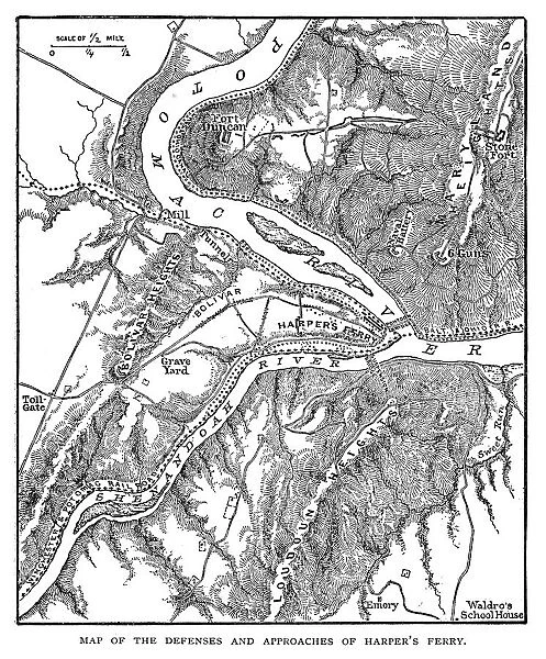
Map of the defenses and approaches of Harpers Ferry during the American Civil War
![]()

Wall Art and Photo Gifts from Fine Art Storehouse
Map of the defenses and approaches of Harpers Ferry during the American Civil War
Map of the defenses and approaches of Harpers Ferry during the American Civil War - Scanned 1887 Map
Unleash your creativity and transform your space into a visual masterpiece!
benoitb
Media ID 14719303
© This content is subject to copyright
FEATURES IN THESE COLLECTIONS
> Fine Art Storehouse
> History
> Battles & Wars
> American Civil War (1860-1865)
> Fine Art Storehouse
> Map
> Historical Maps
> Maps and Charts
> Early Maps
EDITORS COMMENTS
This photo print, titled "Map of the defenses and approaches of Harpers Ferry during the American Civil War" takes us on a historical journey back to 1887. The image showcases an intricately scanned map that offers a fascinating glimpse into the strategic military planning during this tumultuous period in American history. The map itself is a testament to meticulous detail and precision, revealing the intricate network of defenses and approaches surrounding Harpers Ferry. As we delve deeper into its lines, symbols, and annotations, we are transported to a time when this small town played a crucial role as both an arsenal for Union forces and a coveted prize for Confederate troops. Through this visual representation, we gain insight into the complex web of fortifications that protected Harpers Ferry from potential attacks. From Fort Duncan's imposing presence to other strategically positioned strongholds dotting the landscape, it becomes evident how critical these defensive measures were in safeguarding this vital location. Benoitb's expert scanning technique has breathed new life into this antique map, allowing us to appreciate its historical significance with remarkable clarity. Whether you're an avid history enthusiast or simply intrigued by cartography's artistry, this print serves as both an educational tool and a stunning piece of artwork that captures our imagination while honoring America's past.
MADE IN AUSTRALIA
Safe Shipping with 30 Day Money Back Guarantee
FREE PERSONALISATION*
We are proud to offer a range of customisation features including Personalised Captions, Color Filters and Picture Zoom Tools
SECURE PAYMENTS
We happily accept a wide range of payment options so you can pay for the things you need in the way that is most convenient for you
* Options may vary by product and licensing agreement. Zoomed Pictures can be adjusted in the Cart.


