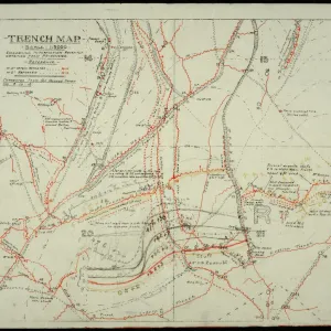
Colour lithograph print of a World War I map






Viewer Controls
- Rotate: Left-click + drag
- Pan: Right-click + drag
- Zoom: Scroll wheel
- Rotate: Swipe
- Zoom: Pinch to Zoom
Framed Prints From Fine Art Finder
This artwork is available as
Framed Print of Map: Sheet 62D SE, Edition 3B (Local), 1:20000, GSGS 2742, 11 July 1918 (colour litho)
NAM3963978 Map: Sheet 62D SE, Edition 3B (Local), 1:20000, GSGS 2742, 11 July 1918 (colour litho) by English School, (20th century); National Army Museum, London; (add.info.: This map of the Amiens area is annotated to show the stop and start lines and approach to the night attack on Proyart, August 1918.
It belonged to Captain Daniel Hickey of the Tank Corps who led No. 7 Section of B' Company, 8th Tank Battalion, during the Battle of Amiens (8-12 August 1918). The Proyart operation was the first ever night attack by tanks, but it was poorly planned and resulted in heavy casualties for the tank crews and supporting infantry.); National Army Museum, London, UK.
Artwork Licensed From Fine Art Finder (www.bridgemanimages.com)
Your chosen combination is quickly and professionally made to order - Shipping & Delivery Details
If you are not entirely happy with your items, simply return them to us within 30 days for a replacement or full refund - 30 Day Returns
Media ID 51447848
Editors Comments
Framed Prints of vintage maps offer a unique decorative option. This Framed Print features a colour lithograph map from 1918, produced by the English School for the National Army Museum. The detailed illustration showcases geographical information on a local scale. Available as Framed Prints, these items can be hung in any room to add visual interest and historical context.
A poignant piece of history, this vintage map captures the intensity and complexity of World War I.
This artwork is also available as...
Photo Prints - High-quality Photo Prints of Map: Sheet 62D SE, Edition 3B (Local), 1:20000, GSGS 2742, 11 July 1918 (colour litho) available for purchase. This vintage map print is a reproduction of an original English School artwork from the National Army Museum collection.
Poster Prints - Poster Prints of Map: Sheet 62D SE, Edition 3B (Local), 1:20000, GSGS 2742, 11 July 1918. Colour lithograph map print featuring a detailed topographical representation from the English School, dated to the early twentieth century.
Metal Prints - Metal Prints of vintage maps offer a unique way to display historical geography. This Metal Print features a detailed colour lithograph map from 1918, showcasing Sheet 62D SE with Edition 3B (Local) scale. The map is part of the GSGS 2742 series and provides a precise representation of the area at that time.
Canvas Prints - Canvas Prints of vintage maps bring a touch of history to any room. This Canvas Print features an English School map from the 20th century, showcasing Sheet 62D SE, Edition 3B (Local), printed in colour litho on July 11, 1918. Perfect for art lovers and history enthusiasts alike, our high-quality Canvas Prints are ideal for home decor or office spaces.
Premium A1 (A2 Poster)
Ready to Hang Contemporary Framed Prints adds style, protection, and a polished touch to your space - effortlessly.
Your artwork will be printed as shown in the preview. To adjust please select Edit Printed Image under the Buy button
Premium Paradise Wooden Range A1 Premium Poster Frame (86x62cm) with A2 Poster (59x42cm) and mounted behind a white matt board to make your photo really stand out. FSC Certified and Rainforest Alliance Certified for environmental, social, and economic sustainably. High transparency tempered glass window with a smooth finished frame. Great for filling empty walls, decorating blank spaces, or creating eye-catching gallery walls. Frames arrive ready to hang. Sent with secure, protective packaging. Smooth wooden veneer mimics the real wood look and feel with ultra-durable scratch resistance tempered glass. Note: measurements provided are estimated outer dimensions, which include both the image and the frame. While we aim to keep sizing consistent, exact dimensions may vary slightly due to differences in print size or production requirements, which may result in a variation in the overall size (up to approximately 2.5cm (1"))
These are individually made so all sizes are approximate
Estimated Image Size (if not cropped) is 58.8cm x 41.4cm (23.1" x 16.3")
Estimated Product Size is 86.6cm x 62cm (34.1" x 24.4")
Features In These Collections
> Fine Art Finder > Artists > English School
> Historic > World War I and II > World War I
> Historic > World War I and II
> Maps and Charts > Early Maps
> Maps and Charts > World