Fraud Blocker Skip to main content

Amazon Region Collection

Explore the enchanting Amazon region, a captivating destination that takes you back in time

Background imageAmazon Region Collection: Brazil map 1895

Brazil map 1895
Meyers Konversations-Lexikon. Ein Nachschlagewerk des allgemeinen Wissens, 5th edition 17 volumes Bibliographisches Institut - Leipzig 1895-1897

Background imageAmazon Region Collection: South America Map Illustration, Travel, Exploration, Antique 1871 Illustration

South America Map Illustration, Travel, Exploration, Antique 1871 Illustration
Color stock photo of an antique South America map illustration. Salvaged from an 1871 geography book

Background imageAmazon Region Collection: Map of South America 19th Century

Map of South America 19th Century
Vintage map of South America from the 19th Century

Background imageAmazon Region Collection: Map of South America

Map of South America, from a Spanish Atlas, 1582

Background imageAmazon Region Collection: Map of South America (early 19th century steel engraving)

Map of South America (early 19th century steel engraving)
A steel engraving of a map from the early 19th century of Brazil and Paraguay in South America, from A System of Geography, Popular and Scientific, or A Physical, Political

Background imageAmazon Region Collection: Antquie Map of South America

Antquie Map of South America
Vintage map of South America from 1837

Background imageAmazon Region Collection: Yellow anaconda (Eunectes notaeus)

Yellow anaconda (Eunectes notaeus)
Illustration of a Yellow anaconda (Eunectes notaeus)

Background imageAmazon Region Collection: Tree trunk of a giant rainforest trees lying on the banks of the Amazon and Rio Solimoes

Tree trunk of a giant rainforest trees lying on the banks of the Amazon and Rio Solimoes, Mamiraua Sustainable Development Reserve in Tefe, Amazonas, Brazil

Background imageAmazon Region Collection: Brazil, Amazon, Rio Tapajos

Brazil, Amazon, Rio Tapajos. A tributary of the Rio Tapajos which is itself a tributary of the Amazon. On its bank a small house of a plantation farmer is crowned with a rainbow

Background imageAmazon Region Collection: Dug out canoe used by local fishermen pulled up on

Dug out canoe used by local fishermen pulled up on the banks of the Rio Tarajos, a tributary of the Amazon River, at sunset in the Amazonas Region of Brazil Dug out canoe used by local fishermen

Background imageAmazon Region Collection: Amazon Lily (Eucharis amazonica)

Amazon Lily (Eucharis amazonica)
Illustration of a Amazon Lily (Eucharis amazonica)

Background imageAmazon Region Collection: Piranha Piraya (Pygocentrus piraya)

Piranha Piraya (Pygocentrus piraya)
Illustration of a Piranha Piraya (Pygocentrus piraya)

Background imageAmazon Region Collection: Herakles (left) and Greek felling a mounted Amazon

Herakles (left) and Greek felling a mounted Amazon from Temple of Apollo Epikourios at Bassae

Background imageAmazon Region Collection: Opisthocomus hoatzin, Hoatzin perched on a tree branch, side view

Opisthocomus hoatzin, Hoatzin perched on a tree branch, side view

Background imageAmazon Region Collection: Mexican Red-kneed Tarantula (Brachypelma smithi), bird-eating spider

Mexican Red-kneed Tarantula (Brachypelma smithi), bird-eating spider

Background imageAmazon Region Collection: Common Morpho butterfly (morpho peleides)

Common Morpho butterfly (morpho peleides)

Background imageAmazon Region Collection: Illustration of tropical rainforest with bird perched on branch

Illustration of tropical rainforest with bird perched on branch

Background imageAmazon Region Collection: Amazon rainforest, Belem, state of Para, Brazil, South America

Amazon rainforest, Belem, state of Para, Brazil, South America

Background imageAmazon Region Collection: Bank of the Rio Solimoes river with flooded Varzea forest, Mamiraua National Park, Manaus

Bank of the Rio Solimoes river with flooded Varzea forest, Mamiraua National Park, Manaus, Amazonas, Brazil

Background imageAmazon Region Collection: Giant rainforest tree in the flooded Varzea forest, Mamiraua National Park, Manaus, Amazonas, Brazil

Giant rainforest tree in the flooded Varzea forest, Mamiraua National Park, Manaus, Amazonas, Brazil

Background imageAmazon Region Collection: Jungle giant in the Varzea forests, Mamiraua-Nationalpark, Manaus, Amazonas State, Brazil

Jungle giant in the Varzea forests, Mamiraua-Nationalpark, Manaus, Amazonas State, Brazil

Background imageAmazon Region Collection: Dusk at a lake-like widened part of the Amazon or Rio Solimoes

Dusk at a lake-like widened part of the Amazon or Rio Solimoes, Mamiraua Sustainable Development Reserve, Manaus, Amazonas, Brazil

Background imageAmazon Region Collection: Typical floating house for the Amazon, Tefe, Amazonas Province, Brazil

Typical floating house for the Amazon, Tefe, Amazonas Province, Brazil

Background imageAmazon Region Collection: White-fronted Capuchin -Cebus albifrons-, Mamiraua Sustainable Development Reserve, Amazonas, Brazil

White-fronted Capuchin -Cebus albifrons-, Mamiraua Sustainable Development Reserve, Amazonas, Brazil

Background imageAmazon Region Collection: Centipede, Amazon Rainforest, Peru

Centipede, Amazon Rainforest, Peru

Background imageAmazon Region Collection: Tortoise

Tortoise
Yellow-footed Tortoise. species - testudinidae

Background imageAmazon Region Collection: Tortoise

Tortoise
Yellow-footed Tortoise. species - testudinidae

Background imageAmazon Region Collection: State of Amazonas, Brazil, True Colour Satellite Image

State of Amazonas, Brazil, True Colour Satellite Image
Satellite view of the State of Amazonas, Brazil. This image was compiled from data acquired by LANDSAT 5 & 7 satellites

Background imageAmazon Region Collection: State of Amapa, Brazil, True Colour Satellite Image

State of Amapa, Brazil, True Colour Satellite Image
Satellite view of the State of Amapa, Brazil. This image was compiled from data acquired by LANDSAT 5 & 7 satellites

Background imageAmazon Region Collection: State of Tocantins, Brazil, Relief Map

State of Tocantins, Brazil, Relief Map
Relief map of the State of Tocantins, Brazil. This image was compiled from data acquired by LANDSAT 5 & 7 satellites combined with elevation data

Background imageAmazon Region Collection: State of Para, Brazil, True Colour Satellite Image

State of Para, Brazil, True Colour Satellite Image
Satellite view of the State of Para, Brazil. This image was compiled from data acquired by LANDSAT 5 & 7 satellites

Background imageAmazon Region Collection: Suriname, Relief Map with Border and Mask

Suriname, Relief Map with Border and Mask
Relief map of Suriname (with border and mask). This image was compiled from data acquired by landsat 5 & 7 satellites combined with elevation data

Background imageAmazon Region Collection: Venezuela, Relief Map with Border and Mask

Venezuela, Relief Map with Border and Mask
Relief map of Venezuela (with border and mask). This image was compiled from data acquired by landsat 5 & 7 satellites combined with elevation data

Background imageAmazon Region Collection: State of Tocantins, Brazil, True Colour Satellite Image

State of Tocantins, Brazil, True Colour Satellite Image
Satellite view of the State of Tocantins, Brazil. This image was compiled from data acquired by LANDSAT 5 & 7 satellites

Background imageAmazon Region Collection: Guyana, Relief Map With Border and Mask

Guyana, Relief Map With Border and Mask
Relief map of Guyana (with border and mask). This image was compiled from data acquired by landsat 5 & 7 satellites combined with elevation data

Background imageAmazon Region Collection: State of Amazonas, Brazil, Relief Map

State of Amazonas, Brazil, Relief Map
Relief map of the State of Amazonas, Brazil. This image was compiled from data acquired by LANDSAT 5 & 7 satellites combined with elevation data

Background imageAmazon Region Collection: State of Mato Grosso do Sul, Brazil, True Colour Satellite Image

State of Mato Grosso do Sul, Brazil, True Colour Satellite Image
Satellite view of the State of Mato Grosso do Sul, Brazil. This image was compiled from data acquired by LANDSAT 5 & 7 satellites

Background imageAmazon Region Collection: Peru, Relief Map With Border and Mask

Peru, Relief Map With Border and Mask
Relief map of Peru (with border and mask). This image was compiled from data acquired by landsat 5 & 7 satellites combined with elevation data

Background imageAmazon Region Collection: State of Para, Brazil, Relief Map

State of Para, Brazil, Relief Map
Relief map of the State of Para, Brazil. This image was compiled from data acquired by LANDSAT 5 & 7 satellites combined with elevation data

Background imageAmazon Region Collection: Ecuador, Relief Map With Border and Mask

Ecuador, Relief Map With Border and Mask
Relief map of Equator (with border and mask). This image was compiled from data acquired by landsat 5 & 7 satellites combined with elevation data

Background imageAmazon Region Collection: State of Mato Grosso do Sul, Brazil, Relief Map

State of Mato Grosso do Sul, Brazil, Relief Map
Relief map of the State of Mato Grosso do Sul, Brazil. This image was compiled from data acquired by LANDSAT 5 & 7 satellites combined with elevation data

Background imageAmazon Region Collection: State of Amapa, Brazil, Relief Map

State of Amapa, Brazil, Relief Map
Relief map of the State of Amapa, Brazil. This image was compiled from data acquired by LANDSAT 5 & 7 satellites combined with elevation data

Background imageAmazon Region Collection: Brazil, Relief Map With Border and Mask

Brazil, Relief Map With Border and Mask
Relief map of Brazil (with border and mask). This image was compiled from data acquired by landsat 5 & 7 satellites combined with elevation data

Background imageAmazon Region Collection: Bolivia, Relief Map With Border and Mask

Bolivia, Relief Map With Border and Mask
Relief map of Bolivia (with border and mask). This image was compiled from data acquired by landsat 5 & 7 satellites combined with elevation data

Background imageAmazon Region Collection: Indian fishing with bow and arrow, Xingu, Amazon region, Brazil, South America

Indian fishing with bow and arrow, Xingu, Amazon region, Brazil, South America


All Professionally Made to Order for Quick Shipping

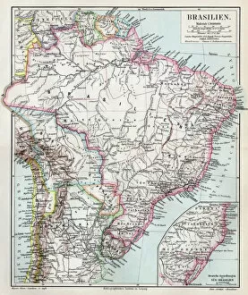
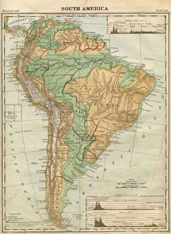
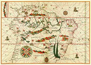
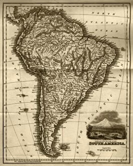
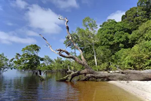
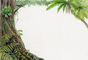
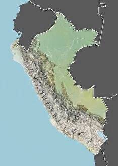
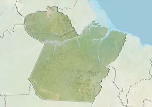
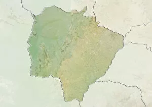
Explore the enchanting Amazon region, a captivating destination that takes you back in time. Immerse yourself in the rich history and natural wonders of this vast land, as depicted on an antique 1871 illustration of South America. Marvel at the intricate details of a Brazil map from 1895, tracing your finger along the contours of this breathtaking landscape. Embark on a journey through dense rainforests and winding rivers, guided by a South America map illustration that ignites your sense of adventure. Discover hidden gems like Rio Tapajos and Jamaraqua, where untouched beauty meets untamed wilderness. Let your curiosity lead you to Rio Tarajos, where vibrant cultures intertwine with nature's magnificence. As you traverse this ancient land, encounter fascinating creatures such as the mesmerizing yellow anaconda slithering gracefully through its habitat. Witness awe-inspiring scenes like giant tree trunks resting peacefully on the banks of the Amazon and Rio Solimoes within Mamiraua Sustainable Development Reserve in Tefe, Brazil. Feel transported to another era as you study an early 19th-century steel engraving showcasing South America's diverse topography. Allow yourself to be captivated by an antique map depicting every corner of this remarkable continent. The Amazon region beckons explorers seeking unparalleled beauty and cultural richness. Uncover its secrets as you navigate through time-honored landscapes filled with wonderment and endless possibilities for discovery.